Plizio Visual Lab
Iruya
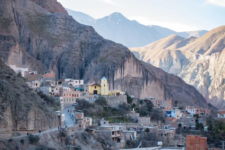
Iruya is an isolated Andean settlement perched dramatically on a steep mountain ledge at 2,780 meters above sea level. Although geographically located in the Salta province, the town is completely inaccessible from Salta itself; it can only be reached by traveling through the neighboring Jujuy province along a rugged dirt road crossing a 4,000-meter mountain pass. The town's origins date back to the 17th century. Its narrow, steeply inclined cobblestone streets wind between small adobe and stone houses. The focal point of the village is the Our Lady of the Rosary church with its distinctive pale blue dome, standing directly against the backdrop of imposing vertical cliffs. Iruya maintains a strong Kolla indigenous cultural identity. Traditional agricultural terraces are still used along the riverbanks below the town. The most significant annual event is the feast of the Pachamama in August, where ancient Andean rituals blend with Catholic traditions in an animated multi-day celebration.
- Location: Argentina
- Top sights: AWAWA · Mirador de la Cruz · Museo Popular de Iruya
- Nearby: Palpalá (68 km)
Geography
Facts
- Located in Salta province
- Perched on a steep cliff at 2,780m
- Only accessible via Jujuy province
- 17th-century origins
- Kolla indigenous culture
- Our Lady of the Rosary church
- Cobblestone streets
- Traditional agricultural terraces
Explore nearby
Notable places around
Route planner — Car & Motorhome
Where do you start? We build the route here, with stops and country notes along the way.
© OpenStreetMap contributors · OpenRouteService
Sights in the town Iruya (6)
Frequently asked questions
Iruya: where is it located?
Iruya: what is there to see?
Iruya: why is it worth visiting?

Nearby cities