Plizio Visual Lab
Dyrhólaey
Plizio editorial teamData Sources
Landmark
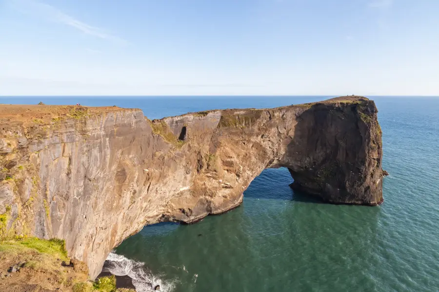
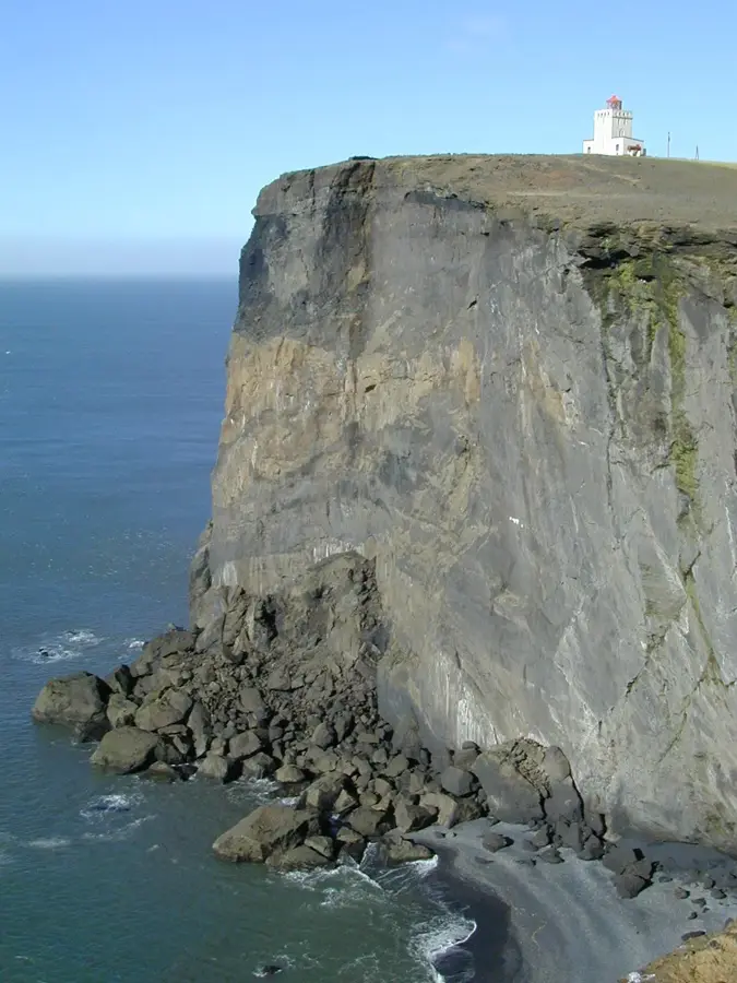
Dyrhólaey is a massive promontory on the southern coast of Iceland, located near the village of Vík í Mýrdal and rising 120 meters above the Atlantic Ocean. This geological formation originated approximately 100,000 years ago during a submarine eruption in the late Pleistocene epoch. It is world-renowned for its gigantic basalt arch, which was carved by the relentless erosion of the ocean waves and gave the site its name, meaning 'the hill with the door hole.' Since 1978, the area has been a protected nature reserve to safeguard its delicate vegetation and the significant breeding colonies of seabirds, particularly Atlantic puffins and fulmars. Atop the cliff sits a distinctive square lighthouse built in 1927, which remains an active navigational aid for maritime traffic. From its summit, visitors can enjoy panoramic views of the black sand beaches of Reynisfjara to the east and the vast coastline stretching toward the west. The site serves as a prime example of both Iceland's volcanic origins and the powerful erosive forces of the North Atlantic.
- Location: Iceland
- Top sights: Dyrhólaey · Dyrhólaey Lighthouse · Kirkjufjara Beach
- Nearby: Vik (6 km)
Best time to visit & climate
The most pleasant time to visit is Jun–Aug.
| Jan | Feb | Mar | Apr | May | Jun | Jul | Aug | Sep | Oct | Nov | Dec | |
|---|---|---|---|---|---|---|---|---|---|---|---|---|
| Avg °C | 1 | 1 | 1 | 3 | 5 | 8 | 10 | 10 | 8 | 4 | 2 | 1 |
| Rain mm | 250 | 232 | 222 | 174 | 124 | 120 | 144 | 166 | 229 | 235 | 221 | 251 |
📋 Practical info
Visiting
Dyrhólaey is a peninsula on the South Coast accessible year-round except during strong winds. Visitors can view the arch and cliffs from viewpoints; the lighthouse is also accessible.
Typical hours
The site has no fixed hours and is accessible day and night, but the access road may close in bad weather. During summer months, the area may be closed for nesting birds - please obey signage.
Photography
Photography is allowed everywhere; the natural rock arch and black sand beach provide iconic subjects. A telephoto lens is good for close-ups of puffins that nest here in summer.
Time needed
Most visitors spend 20-30 minutes on the peninsula. If you also visit nearby Reynisfjara beach, plan an additional hour.
Combine with
Combine Dyrhólaey with the black sand beach Reynisfjara and the Reynisdrangar basalt sea stacks. Nearby Skógafoss waterfall and the village of Vík are also on the South Coast route.
Getting there
Dyrhólaey is about 15 kilometers west of Vík on the Ring Road (Route 1). Access is via a gravel road (Route 218); a car is necessary as there is no bus service.
Insider tip
Visit Dyrhólaey in the late afternoon when the light best highlights the rock arch. Be mindful of bird nesting areas - stay on marked paths to avoid disturbing puffins.
Geography
Facts
- The promontory was formed about 100,000 years ago by a submarine eruption.
- Dyrhólaey was officially designated as a nature reserve in 1978.
- The distinctive square lighthouse on the cliff was completed in 1927.
- The cliffs reach a maximum elevation of 120 meters above sea level.
- The name Dyrhólaey translates to 'door-hole island' or 'hill with a door hole'.
- Access is often restricted during the puffin nesting season from May to June.
Explore nearby
Notable places around
Route planner — Car & Motorhome
Where do you start? We build the route here, with stops and country notes along the way.
Vehicle
Only stops with (optional):
© OpenStreetMap contributors · OpenRouteService
Sights in the town Dyrhólaey (4)
Sights nearby
Frequently asked questions
When can puffins be seen here?
The birds nest here on the cliffs from May to mid-August.
Is a 4x4 vehicle required?
No, the road to the lighthouse and the parking lot is paved.
Are there restrictions during nesting season?
Yes, in May and June, access may be limited for bird protection.
Is there a parking fee?
Currently, parking at the Dyrhólaey lighthouse is free.
Can you walk on the beach below the cliffs?
Yes, Reynisfjara beach is accessible, but beware of unpredictable waves.
Dyrhólaey: where is it located?
Dyrhólaey is located in Iceland.
Dyrhólaey: what is there to see?
Highlights include Dyrhólaey, Dyrhólaey Lighthouse, Kirkjufjara Beach.
Dyrhólaey: when is the best time to visit?
The most pleasant time to visit is Jun, Aug.
Dyrhólaey: why is it worth visiting?
Dyrhólaey is a massive promontory on the southern coast of Iceland, located near the village of Vík í Mýrdal and rising 120 meters above the Atlantic Ocean.

Explore with Plizio
Discover more places in Europe
More places in Iceland →
Nearby cities

Reykjavík
Reykjavík is the capital and largest city of Iceland, serving as the nation's cultural, economic, and governmental hub.

Kópavogur
Kópavogur is Iceland's second largest city, located directly south of Reykjavík.

Hafnarfjörður
A charming port town just outside Reykjavík, known as the 'town in the lava' and famous for its Viking heritage and elf folklore.

Hafnarfjörður
Hafnarfjörður is a port city south of Reykjavík, built on an ancient lava field.

Keflavík
Keflavík is a town on the Reykjanes Peninsula, part of the Reykjanesbær municipality.

Mosfellsbær
Mosfellsbær is located northeast of Reykjavík, known for its hilly landscape and thermal springs.

Garðabær
Garðabær is a growing town in the Greater Reykjavík area.

Selfoss
Selfoss is the largest service center in southern Iceland, situated on the banks of the Ölfusá River.

Akranes
Akranes is a port town on Iceland's west coast, known for its long fishing tradition and two distinctive lighthouses.

Seltjarnarnes
Seltjarnarnes is a small municipality on a peninsula just west of Reykjavík.

Vestmannaeyjar
Vestmannaeyjar is a town on Heimaey island in the archipelago of the same name off Iceland's south coast.

Grindavík
Grindavík is a fishing town on the south coast of the Reykjanes Peninsula.

Blue Lagoon (Grindavík)
Iceland's most famous geothermal spa, known for its milky-blue, mineral-rich waters.

Hveragerði
Hveragerði is famous for its high geothermal activity, located about 45 km east of Reykjavík.

Hveragerði
Known as the 'Greenhouse Town', it sits on an active geothermal field and is famous for its hot springs and banana cultivation.
History & landmarks

Reykjavík City Hall
Reykjavík City Hall is situated on the banks of Lake Tjörnin.

Hvolsvöllur
A historic town in South Iceland, famous as the heart of the Njál's Saga and a gateway to glaciers.
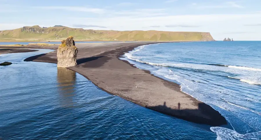
Reynisfjara
Reynisfjara is a world-famous black sand beach on the South Coast of Iceland.

Skógar
A historic village on the South Coast, famous for the powerful Skógafoss waterfall and its folk museum.
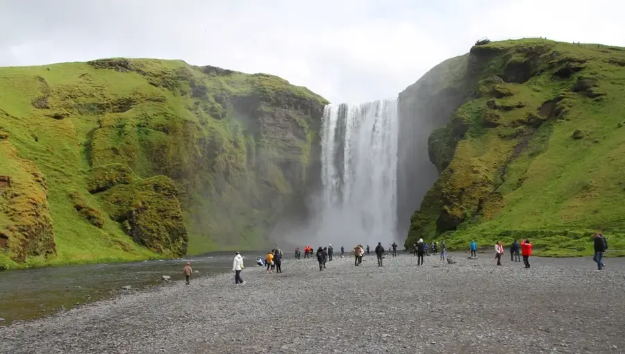
Skógafoss
Skógafoss is one of Iceland's largest waterfalls with a width of 25 meters.
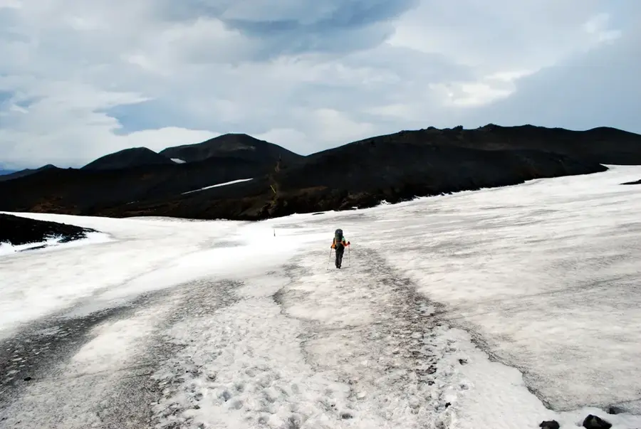
Fimmvörðuháls
Fimmvörðuháls is a mountain pass between the Eyjafjallajökull and Mýrdalsjökull glaciers.
Nature
More places
Víkurkirkja
Víkurkirkja is the white church with a red roof overlooking the village of Vík í Mýrdal.
Skógar Museum
Skógar Museum is a cultural heritage museum in southern Iceland with an extensive collection of artifacts and historic turf houses.
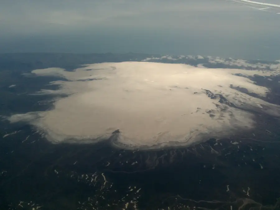
Mýrdalsjökull
Mýrdalsjökull is a prominent glacier in southern Iceland.
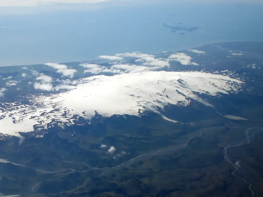
Eyjafjallajökull
Eyjafjallajökull is a smaller glacier in southern Iceland covering a stratovolcano of the same name.
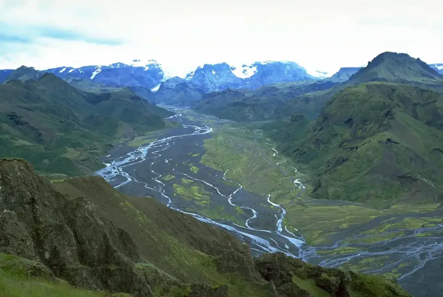
Þórsmörk
Þórsmörk, or Thor's Wood, is a mountain valley in southern Iceland surrounded by three glaciers.