Plizio Visual Lab
Kéniéba Plateau

Weather…
Water temperature…
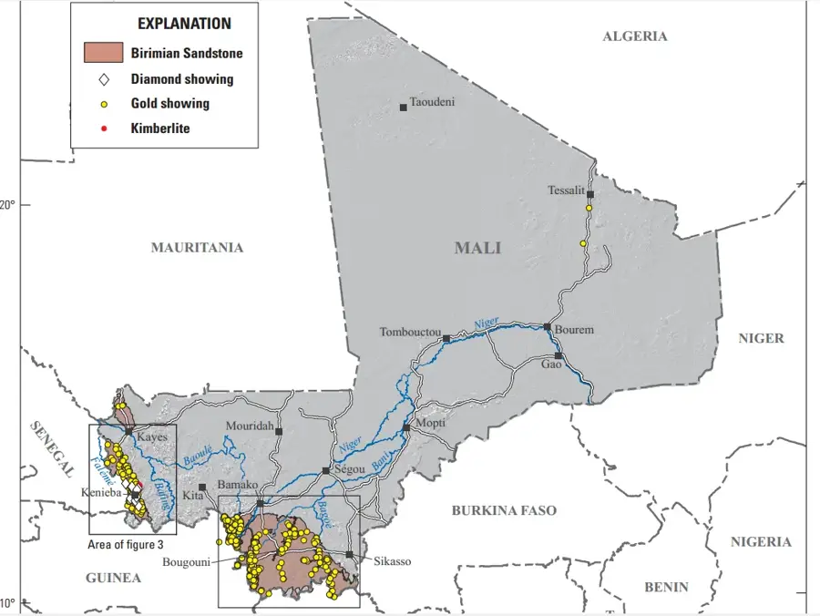
The Kéniéba Plateau is located in the far southwestern corner of Mali, near the borders with Senegal and Guinea, and is geologically part of the Fouta Djallon massif. This highland region is characterized by higher rainfall levels compared to the rest of the country, supporting a denser vegetation cover and wooded savannahs. The plateau is globally renowned for its vast gold deposits, which have been exploited since the medieval era of the ancient Ghana Empire. The landscape features rugged mountains, scenic waterfalls, and deep river valleys carved by tributaries of the Senegal River, such as the Falémé. Average elevations range from 400 to 600 meters, creating a distinct topographical contrast with the flatter regions to the east. Ethnically, the area is primarily inhabited by the Malinké people, whose cultural history is deeply intertwined with the expansion of the Mali Empire. In recent decades, industrial gold mining has significantly altered the region's socioeconomic landscape, although traditional artisanal mining remains a common practice among locals.
- Location: Mali
- Nearby: Kéniéba (19 km)
Best time to visit & climate
The most pleasant time to visit is Jan, Nov, Dec.
| Jan | Feb | Mar | Apr | May | Jun | Jul | Aug | Sep | Oct | Nov | Dec | |
|---|---|---|---|---|---|---|---|---|---|---|---|---|
| Avg °C | 25 | 29 | 32 | 34 | 34 | 30 | 27 | 26 | 26 | 27 | 25 | 24 |
| Rain mm | 1 | 1 | 2 | 4 | 39 | 146 | 255 | 361 | 254 | 81 | 5 | 0 |
📋 Practical info
Geography
Facts
- The Kéniéba region hosts some of the largest gold mines in West Africa.
- The plateau is part of the Precambrian Birimian greenstone belt.
- Average elevations range between 400 and 600 meters above sea level.
- The Falémé River forms the natural border with Senegal in this area.
- Annual rainfall in the region often exceeds 1,200 mm.
- The town of Kéniéba is situated approximately 480 kilometers west of Bamako.
Explore nearby
Notable places around
Route planner — Car & Motorhome
Where do you start? We build the route here, with stops and country notes along the way.
© OpenStreetMap contributors · OpenRouteService
Sights nearby
Frequently asked questions
How difficult is hiking on the Kéniéba-Plateau?
When should one visit the plateau?
Are there accommodations or dining options on the plateau?
Can the area be explored well by car?
What is the climate like on the plateau?
Kéniéba Plateau: where is it located?
Kéniéba Plateau: when is the best time to visit?
Kéniéba Plateau: why is it worth visiting?

Nearby cities

History & landmarks
More places