Plizio Visual Lab
Falea Uranium Project
Weather…
Water temperature…
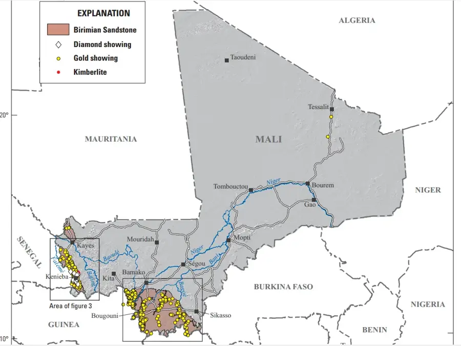
The Falea Uranium Project in southwestern Mali stands as a premier example of a high-potential polymetallic deposit in West Africa, uniquely integrating uranium, copper, and silver within its geological structures. Located in the Kenieba Cercle of the Kayes Region, the project is situated near the tri-border area where Mali meets Guinea and Senegal, providing it with a complex geopolitical and economic context. Geologically, Falea is characterized by its sandstone-hosted mineralization within the Taoudeni Basin, with deposits typically found at depths ranging from 150 to 450 meters beneath the surface. The exploration history of the site dates back to the initial surveys conducted by the French group COGEMA in the late 1970s, though comprehensive resource definition was only achieved in the 21st century through modern drilling programs led by Rockgate Capital and GoviEx Uranium. The presence of significant copper and silver concentrations alongside uranium provides a robust economic buffer, enhancing the project's feasibility across various commodity price cycles. Beyond its industrial scale, the development of Falea is expected to drive substantial infrastructure growth in one of Mali's more remote regions, potentially transforming the local socio-economic landscape through job creation and the establishment of new supply chains for the energy sector.
- Location: Mali
- Nearby: Kéniéba (61 km)
Best time to visit & climate
The most pleasant time to visit is Jan, Nov, Dec.
| Jan | Feb | Mar | Apr | May | Jun | Jul | Aug | Sep | Oct | Nov | Dec | |
|---|---|---|---|---|---|---|---|---|---|---|---|---|
| Avg °C | 26 | 29 | 31 | 34 | 33 | 29 | 26 | 26 | 26 | 26 | 26 | 25 |
| Rain mm | 1 | 1 | 2 | 7 | 51 | 151 | 258 | 380 | 254 | 95 | 7 | 0 |
📋 Practical info
Geography
Facts
- 80 km south of Kenieba town
- Minerals: Uranium, Copper, Silver
- Depth range: 200 to 400 meters
- First exploration: 1977
- Geological setting: Taoudeni Basin
- Lead company: GoviEx Uranium
Explore nearby
Notable places around
Route planner — Car & Motorhome
Where do you start? We build the route here, with stops and country notes along the way.
© OpenStreetMap contributors · OpenRouteService
Sights nearby
Frequently asked questions
What is the Falea uranium project?
Is the project open to the public?
How is the local environment protected?
Why is Falea economically important?
What is the infrastructure like in the remote region?
Falea Uranium Project: where is it located?
Falea Uranium Project: when is the best time to visit?
Falea Uranium Project: why is it worth visiting?