Plizio Visual Lab
Kamen Fortress Site
Weather…
Water temperature…
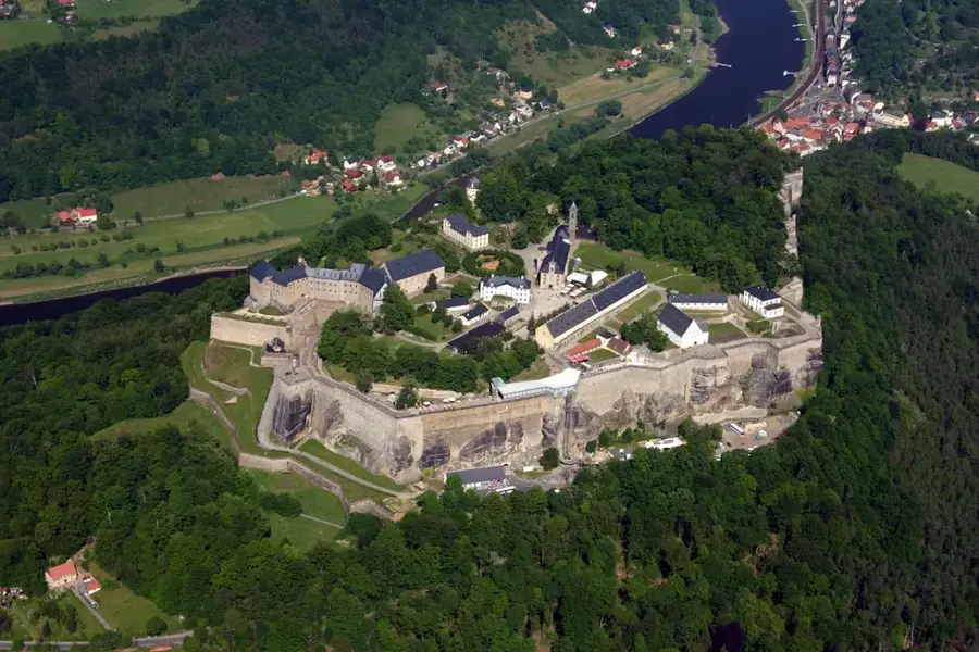
The site of Kamen Fortress is distinguished by its extraordinary natural defensive position, which has made it a coveted strategic post since ancient times. Situated on an isolated limestone plateau, the location is protected by steep precipices on three sides, requiring only minimal man-made reinforcements. Historically, this site was the key to monitoring the Prača Valley, a primary artery for transit between the Adriatic coast and the Balkan interior. Geological surveys indicate that the builders quarried local stone directly on-site, integrating the fortress almost seamlessly into the surrounding landscape. On clear days, the strategic line of sight extends to neighboring Pavlović family strongholds, suggesting a coordinated signaling system during the Middle Ages. Although the structures are largely ruined today, the topography of the terrain still clearly suggests the former complexity of the site, including forecourts, cisterns, and defensive moats.
- Location: Bosnia and Herzegovina
- Nearby: Kneževo (16 km)
Best time to visit & climate
The most pleasant time to visit is Jun–Aug.
| Jan | Feb | Mar | Apr | May | Jun | Jul | Aug | Sep | Oct | Nov | Dec | |
|---|---|---|---|---|---|---|---|---|---|---|---|---|
| Avg °C | -1 | 0 | 4 | 9 | 14 | 18 | 21 | 21 | 15 | 11 | 6 | 0 |
| Rain mm | 73 | 70 | 68 | 71 | 87 | 82 | 58 | 63 | 86 | 79 | 88 | 84 |
📋 Practical info
Geography
Facts
- The limestone plateau provides natural protection via cliffs on three sides.
- The location controlled access to the strategically vital Prača Valley.
- Construction materials were quarried directly from the plateau's rock.
- Visual links existed between this site and other Pavlović strongholds.
- The entire complex covers an area of several hectares.
- Archaeological cisterns demonstrate the site's self-sufficient water supply.
Explore nearby
Notable places around
Route planner — Car & Motorhome
Where do you start? We build the route here, with stops and country notes along the way.
© OpenStreetMap contributors · OpenRouteService
Sights nearby
Frequently asked questions
What does the Kamen site include?
Is the site suitable for picnics?
Are there trash cans there?
What is the ground condition like?
Why should you visit this place?
Kamen Fortress Site: where is it located?
Kamen Fortress Site: when is the best time to visit?
Kamen Fortress Site: why is it worth visiting?
Nearby cities