Plizio Visual Lab
Hutyn Tomnatyk
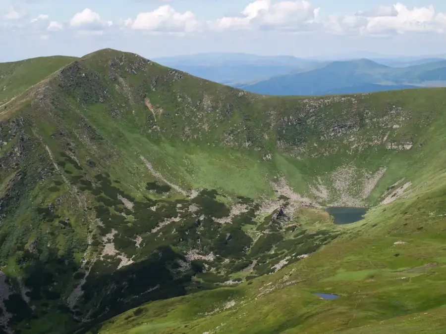
Mount Hutyn Tomnatyk is one of the highest peaks in the Ukrainian Carpathians, standing at an elevation of 2,016 meters in the Chornohora range. It is located very close to Mount Brebeneskul and overlooks the famous glacial lake of the same name. The mountain's name has ancient Daco-Romanian origins, roughly translating to 'the summit that turns grey in autumn or winter.' Its landscape is characterized by steep, rugged cliffs and deep glacial basins formed during the Pleistocene epoch. The subalpine zone of Hutyn Tomnatyk is renowned for its high biodiversity, including rare species of mountain peonies and alpine grasses. It remains a key destination for high-altitude trekking, offering some of the most dramatic and photogenic views of the high Carpathian landscape.
- Location: Ukraine
- Nearby: Verkhovyna (20 km)
Best time to visit & climate
The most pleasant time to visit is Jun–Aug.
| Jan | Feb | Mar | Apr | May | Jun | Jul | Aug | Sep | Oct | Nov | Dec | |
|---|---|---|---|---|---|---|---|---|---|---|---|---|
| Avg °C | -7 | -5 | -1 | 6 | 11 | 15 | 17 | 17 | 12 | 6 | 1 | -4 |
| Rain mm | 51 | 51 | 65 | 66 | 114 | 125 | 120 | 80 | 76 | 69 | 56 | 55 |
📋 Practical info
Geography
Facts
- Hutyn Tomnatyk reaches an altitude of 2,016 meters.
- It is ranked as the 5th highest peak in the country.
- The name is of Daco-Romanian origin, signifying 'winter grey peak'.
- The mountain features steep northern walls carved by glaciers.
- It is a habitat for the rare Rhododendron myrtifolium.
- The summit is a major waypoint for the Chornohora ridge trail.
Explore nearby
Notable places around
Route planner — Car & Motorhome
Where do you start? We build the route here, with stops and country notes along the way.
© OpenStreetMap contributors · OpenRouteService
Sights in the town Hutyn Tomnatyk (1)
Sights nearby
Frequently asked questions
How high is Hutyn Tomnatyk?
Which lake is nearby?
In which region is the mountain located?
How is the trail to the summit?
When should you climb it?
Hutyn Tomnatyk: where is it located?
Hutyn Tomnatyk: when is the best time to visit?
Hutyn Tomnatyk: why is it worth visiting?

Nearby cities