Plizio Visual Lab
Hantangang River Geopark
Weather…
Water temperature…
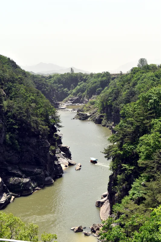
The Hantangang River UNESCO Global Geopark is located in the northern part of South Korea, covering areas in Cheorwon, Pocheon, and Yeoncheon. It is unique in Korea for its volcanic landscapes formed along the 141-kilometer-long Hantangang River. The dominant geological feature consists of basalt columns and columnar joints formed by Quaternary volcanic eruptions between approximately 540,000 and 120,000 years ago. The river has cut deeply into the volcanic plateau, creating spectacular gorges and waterfalls, such as the 15-meter-high Bidulginang Cascade. The region also holds significant historical importance, having served as a strategic point during the Korean War and hosting numerous Paleolithic archaeological sites. In 2020, the site received international recognition from UNESCO for its geological diversity and conservation efforts.
- Location: South Korea
- Top sights: DMZ Tours · Dopiansa
- Nearby: Pocheon (23 km)
Best time to visit & climate
The most pleasant time to visit is May, Jun, Sep.
| Jan | Feb | Mar | Apr | May | Jun | Jul | Aug | Sep | Oct | Nov | Dec | |
|---|---|---|---|---|---|---|---|---|---|---|---|---|
| Avg °C | -7 | -4 | 2 | 8 | 15 | 20 | 23 | 23 | 18 | 11 | 3 | -5 |
| Rain mm | 20 | 31 | 36 | 72 | 84 | 116 | 372 | 282 | 140 | 61 | 55 | 23 |
📋 Practical info
Geography
Facts
- The area was designated as a UNESCO Global Geopark in July 2020.
- The Hantangang River has a total length of 141 kilometers.
- The basalt formations date back between 120,000 and 540,000 years.
- Bidulginang Falls is approximately 15 meters in height.
- Acheulean-style hand axes were discovered in Yeoncheon in 1978.
- Volcanic activity originated from Mount Orisan in present-day North Korea.
Explore nearby
Notable places around
Route planner — Car & Motorhome
Where do you start? We build the route here, with stops and country notes along the way.
© OpenStreetMap contributors · OpenRouteService
Sights in the town Hantangang River Geopark (2)
Sights nearby
Frequently asked questions
What is special about Hantangang Geopark?
Can you go rafting on the Hantangang River?
Are there observation decks there?
Is the park worth visiting in winter?
Are there camping sites nearby?
Hantangang River Geopark: where is it located?
Hantangang River Geopark: what is there to see?
Hantangang River Geopark: when is the best time to visit?
Hantangang River Geopark: why is it worth visiting?

Nearby cities

History & landmarks

More places