Plizio Visual Lab
Drakensberg Amphitheatre

Weather…
Water temperature…
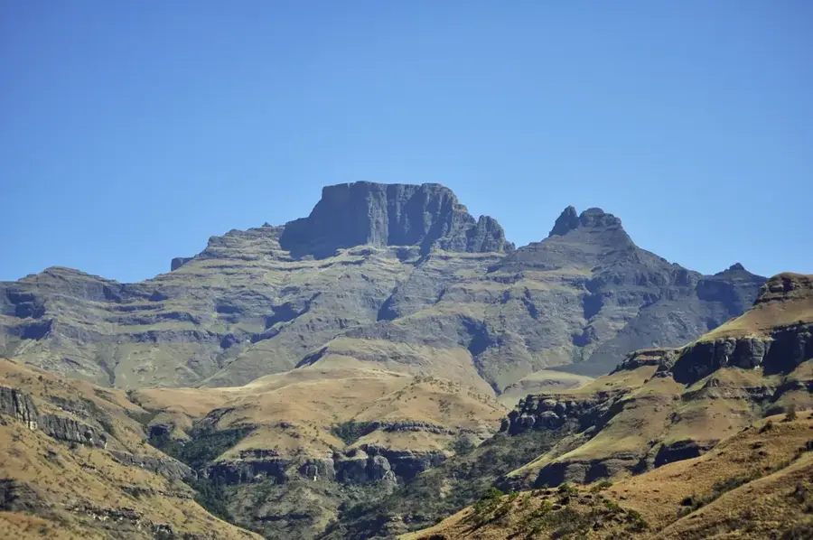
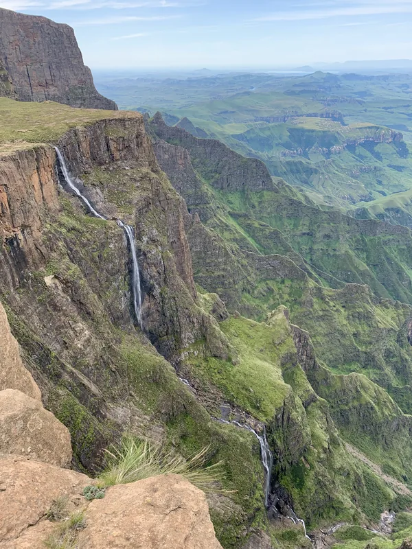
The Drakensberg Amphitheatre is one of the most visually memorable geological features in the world, located within the Royal Natal National Park in KwaZulu-Natal. This colossal rock wall stretches for approximately five kilometers in length and rises nearly 1,220 meters vertically from its base to the plateau. Geologically, the formation consists of a massive basalt cap, created by volcanic activity roughly 180 million years ago, resting on a layer of sedimentary sandstone. Plunging over the cliff's edge is the Tugela Falls, which, at a total drop of 948 meters, is considered one of the highest waterfalls on Earth. The area is a key part of the uKhahlamba-Drakensberg Park, a UNESCO World Heritage site celebrated for its natural grandeur and thousands of ancient San rock paintings. Hikers often reach the summit via a challenging route involving chain ladders at Sentinel Peak, rewarding them with unparalleled views of the landscape below. The environmental conditions on the high plateau are extreme, with regular winter snowfalls and temperatures dropping well below freezing. The Amphitheatre also acts as a primary watershed for the Tugela River, supplying vital water resources to the region and supporting a unique Afro-alpine ecosystem with endemic flora and fauna.
- Location: South Africa
- Top sights: Sugar Loaf · Dooley · Rugged Glen Nature Reserve
- Nearby: Phuthaditjhaba (21 km)
Best time to visit & climate
The most pleasant time to visit is Feb, Sep, Oct.
| Jan | Feb | Mar | Apr | May | Jun | Jul | Aug | Sep | Oct | Nov | Dec | |
|---|---|---|---|---|---|---|---|---|---|---|---|---|
| Avg °C | 18 | 17 | 15 | 12 | 9 | 6 | 6 | 8 | 12 | 15 | 16 | 17 |
| Rain mm | 156 | 122 | 102 | 54 | 14 | 13 | 12 | 21 | 30 | 80 | 109 | 140 |
📋 Practical info
Geography
Facts
- The total length of the cliff face is about 5 kilometers.
- It features a vertical drop of more than 1,220 meters.
- Home to Tugela Falls, dropping a total of 948 meters.
- Formed by volcanic eruptions roughly 180 million years ago.
- Part of the uKhahlamba-Drakensberg UNESCO World Heritage site.
- The summit is accessible via famous chain ladders.
Explore nearby
Notable places around
Route planner — Car & Motorhome
Where do you start? We build the route here, with stops and country notes along the way.
© OpenStreetMap contributors · OpenRouteService
Sights in the town Drakensberg Amphitheatre (6)
Sights nearby
Frequently asked questions
How long is the hike to the Amphitheater?
Is a head for heights required?
When is the best time to visit?
Do I need a permit?
Are there water sources on the way?
Drakensberg Amphitheatre: where is it located?
Drakensberg Amphitheatre: what is there to see?
Drakensberg Amphitheatre: when is the best time to visit?
Drakensberg Amphitheatre: why is it worth visiting?

History & landmarks


Nature
More places