Plizio Visual Lab
Vrelo Bosne
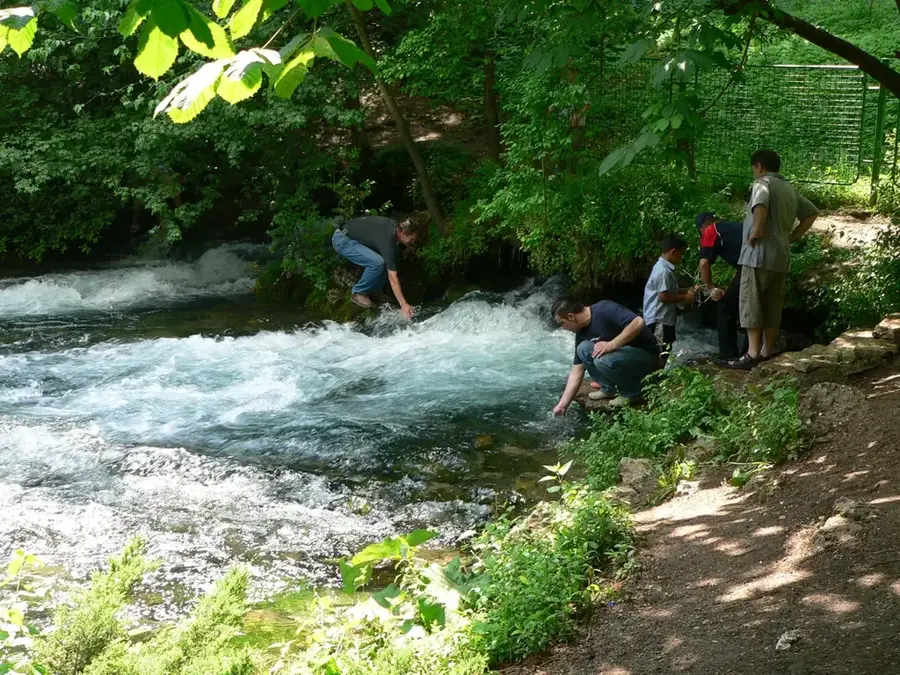
Vrelo Bosne is the source of the Bosna River, situated at the foot of Mount Igman, approximately 12 kilometers southwest of Sarajevo. This protected area covers about 603 hectares and is one of the country's most prominent natural landmarks. The spring emerges in numerous small streams that form crystal-clear ponds inhabited by brown trout. A significant historical and aesthetic feature is the 'Great Alley' (Velika aleja), a 3.5-kilometer walkway lined with 726 plane and chestnut trees, planted during the Austro-Hungarian era. This period also saw the development of elegant villas in the nearby Ilidža municipality, which served as a spa resort for the elite. Today, Vrelo Bosne is a critical drinking water reservoir for Sarajevo and a beloved destination for picnics and nature walks. Small islands within the spring area are connected by wooden bridges, allowing visitors to enjoy the cascading waters and the diverse birdlife in a serene environment.
- Location: Bosnia and Herzegovina
- Top sights: Vrelo Bosne · Nucleus zone - Vrelo Bosne Nature Monument · Crkva Svetog Save
- Nearby: Hadžići (5 km)
Best time to visit & climate
The most pleasant time to visit is Jun–Aug.
| Jan | Feb | Mar | Apr | May | Jun | Jul | Aug | Sep | Oct | Nov | Dec | |
|---|---|---|---|---|---|---|---|---|---|---|---|---|
| Avg °C | -2 | -1 | 2 | 7 | 12 | 16 | 18 | 18 | 13 | 9 | 4 | -1 |
| Rain mm | 63 | 64 | 69 | 69 | 99 | 103 | 75 | 61 | 77 | 71 | 74 | 73 |
📋 Practical info
Geography
Facts
- Protected since: 2006
- Total area: 603 hectares
- Alley length: 3.5 km
- Number of trees in alley: 726
- Location: Ilidža municipality
- Primary river: Bosna
Explore nearby
Notable places around
Route planner — Car & Motorhome
Where do you start? We build the route here, with stops and country notes along the way.
© OpenStreetMap contributors · OpenRouteService
Sights in the town Vrelo Bosne (9)
Vrelo Bosne Nature Monument
Protected area in Bosnia and Herzegovina, includes the Bosna spring and surroundings.
I hearts Stojcevac
Tourist attraction in Stojčevac, heart-shaped sign for photo opportunities.
Rimski most
Roman-era bridge, part of the historical infrastructure in the region.
Roman domus
Roman townhouse, remains of an ancient residential building.
Rimske iskopine
Roman baths, archaeological remains of an ancient thermal complex.
Sights nearby
Frequently asked questions
What is the best way to get to Vrelo Bosne?
How much is the entry fee for the park?
Are there restaurants in the park?
How long does the carriage ride take?
Is the park child-friendly?
Vrelo Bosne: where is it located?
Vrelo Bosne: what is there to see?
Vrelo Bosne: when is the best time to visit?
Vrelo Bosne: why is it worth visiting?
Nearby cities