Plizio Visual Lab
Vorozheska Lake
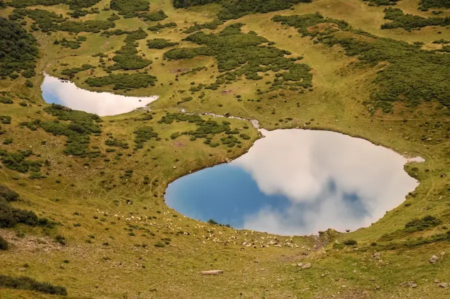
Vorozheska Lake is a high-altitude glacial lake situated in the Svydovets massif of the Ukrainian Carpathians. Located at an elevation of 1460 meters above sea level, it lies within a deep cirque below the slopes of Mount Vorozheska. The lake actually consists of two interconnected basins: a larger, nearly circular pool with a diameter of about 95 meters and a smaller, shallower body of water. The water is remarkably transparent and remains chilly throughout the year, with the maximum depth of the larger basin reaching approximately 4.5 meters. Surrounded by steep grassy slopes and alpine meadows, the area is rich in subalpine flora, including vast fields of blueberries. The lake's name is steeped in local folklore, often associated with words for 'enchantment' or 'sorcery,' and many legends tell of tragic love stories linked to its waters. It serves as a scenic destination for hikers trekking along the popular Svydovets ridge trail.
- Location: Ukraine
- Top sights: Vorozheske · Dohiaska · Velykyi Kotel
- Nearby: Dragobrat (10 km)
Best time to visit & climate
The most pleasant time to visit is Jun–Aug.
| Jan | Feb | Mar | Apr | May | Jun | Jul | Aug | Sep | Oct | Nov | Dec | |
|---|---|---|---|---|---|---|---|---|---|---|---|---|
| Avg °C | -6 | -5 | 0 | 6 | 12 | 15 | 18 | 18 | 13 | 7 | 2 | -4 |
| Rain mm | 56 | 54 | 65 | 61 | 111 | 117 | 113 | 77 | 77 | 70 | 59 | 58 |
📋 Practical info
Geography
Facts
- The lake is situated at an elevation of 1460 meters.
- The main lake basin has a diameter of 95 meters.
- Its maximum depth is recorded at approximately 4.5 meters.
- The surface area of the water is about 0.7 hectares.
- The lake is comprised of two distinct glacial pools.
- The water remains frozen for about 5-6 months of the year.
Explore nearby
Notable places around
Route planner — Car & Motorhome
Where do you start? We build the route here, with stops and country notes along the way.
© OpenStreetMap contributors · OpenRouteService
Sights in the town Vorozheska Lake (3)
Sights nearby
Frequently asked questions
Where is the lake located?
How to reach Vorozheska Lake?
Is swimming allowed in the lake?
Are there camping opportunities?
When is the best time to visit?
Vorozheska Lake: where is it located?
Vorozheska Lake: what is there to see?
Vorozheska Lake: when is the best time to visit?
Vorozheska Lake: why is it worth visiting?

Nearby cities