Plizio Visual Lab
Mount Dovbushanka
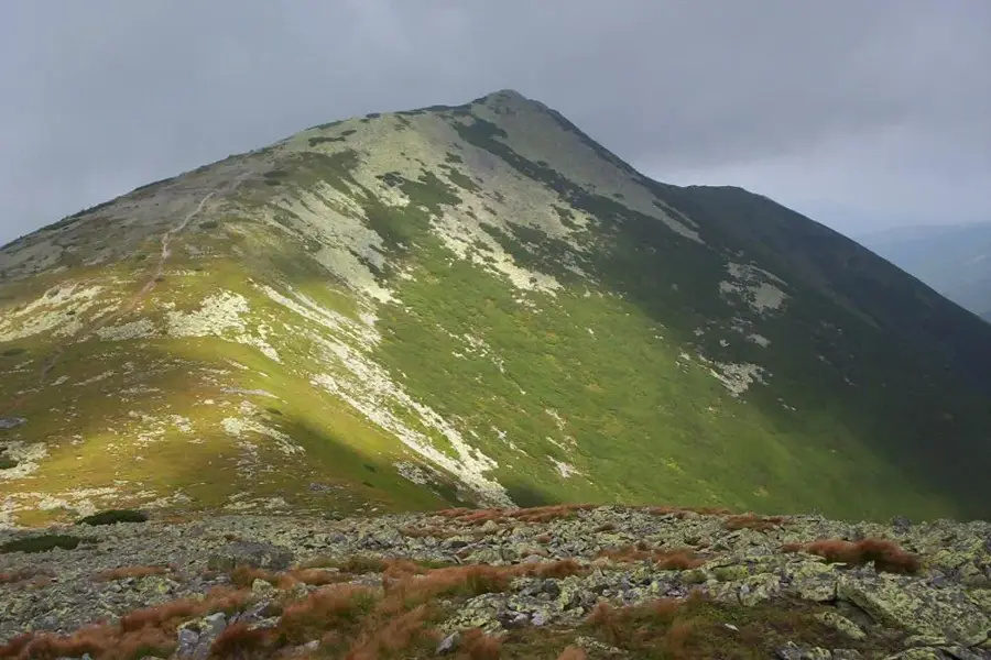
Mount Dovbushanka is one of the most distinctive peaks in the Gorgany range of the Ukrainian Carpathians, rising to an elevation of approximately 1,754 meters above sea level. It is renowned for its vast fields of sandstone boulders, locally called "cekoty," which were formed by intense frost weathering and create a challenging terrain for climbers. The mountain is situated within the Gorgany State Nature Reserve, established in 1996 to safeguard the region's ancient stone pine forests and pristine alpine landscapes. Its name commemorates Oleksa Dovbush, the legendary 18th-century leader of the Opryshky rebels, who is said to have hidden among the area's rocky outcrops. Geologically, the Dovbushanka massif consists of two main summits linked by a narrow, jagged ridge that features panoramic views of the surrounding wilderness. The local climate is notoriously harsh and humid, supporting a unique ecological habitat for rare flora, including the Carpathian edelweiss and various endemic moss species.
- Location: Ukraine
- Top sights: Voda · Dovha · Roller Coaster zipline
- Nearby: Tatariv (15 km)
Best time to visit & climate
The most pleasant time to visit is Jun–Aug.
| Jan | Feb | Mar | Apr | May | Jun | Jul | Aug | Sep | Oct | Nov | Dec | |
|---|---|---|---|---|---|---|---|---|---|---|---|---|
| Avg °C | -6 | -4 | 0 | 6 | 12 | 16 | 18 | 18 | 13 | 7 | 2 | -4 |
| Rain mm | 43 | 45 | 57 | 62 | 111 | 124 | 119 | 78 | 74 | 64 | 48 | 45 |
📋 Practical info
Geography
Facts
- The summit reaches a height of 1,754 meters (5,755 feet).
- Located within the Gorgany Nature Reserve, established in 1996.
- The terrain is defined by large sandstone blocks called 'cekoty'.
- Named after the 18th-century folk hero Oleksa Dovbush.
- The area receives over 1,200 mm of precipitation annually.
- The mountain features a subalpine vegetation zone above 1,500 meters.
Explore nearby
Notable places around
Route planner — Car & Motorhome
Where do you start? We build the route here, with stops and country notes along the way.
© OpenStreetMap contributors · OpenRouteService
Sights in the town Mount Dovbushanka (7)
Roller Coaster zipline📍 landmark
This adventure attraction on Mount Dovbushanka gives a thrilling zipline experience.
Sights nearby
Frequently asked questions
How high is Mount Dovbushanka?
In which mountain range is Dovbushanka located?
Is the climb suitable for beginners?
Are there trail markers on the mountain?
Where does the mountain get its name from?
Mount Dovbushanka: where is it located?
Mount Dovbushanka: what is there to see?
Mount Dovbushanka: when is the best time to visit?
Mount Dovbushanka: why is it worth visiting?

Nearby cities