Plizio Visual Lab
Piz Argient
Weather…
Water temperature…
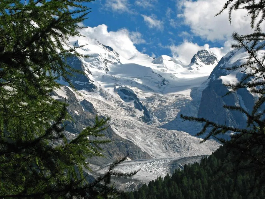
Piz Argient is an imposing, almost entirely glaciated peak in the Bernina Range, standing at 3945 meters. It is located on the border between the Swiss canton of Graubünden and the Italian province of Sondrio, southeast of Piz Bernina. The mountain is a key component of the famous 'Bellavista ridge walk' and forms a prominent double massif along with Piz Zupò. Geologically, it belongs to the Bernina crystalline complex, consisting mainly of diorite and granite. The first recorded ascent took place in 1863 by Seiler and his team. The name 'Argient' (meaning silver) refers to the shimmering appearance of the firn fields that cover the summit year-round. In modern times, Piz Argient is a significant objective for high-altitude mountaineers, typically approached from the Diavolezza or the Marco e Rosa hut. It provides an unparalleled vantage point over Piz Palü and the massive Morteratsch Glacier.
- Location: Switzerland
- Top sights: Punta Marinelli · Crast' Agüzza · Pizzo Roseg
- Nearby: Sils (14 km)
Best time to visit & climate
The most pleasant time to visit is Jun–Aug.
| Jan | Feb | Mar | Apr | May | Jun | Jul | Aug | Sep | Oct | Nov | Dec | |
|---|---|---|---|---|---|---|---|---|---|---|---|---|
| Avg °C | -10 | -10 | -6 | 0 | 5 | 9 | 11 | 11 | 7 | 2 | -3 | -9 |
| Rain mm | 55 | 47 | 61 | 81 | 120 | 129 | 129 | 145 | 99 | 99 | 102 | 65 |
📋 Practical info
Geography
Facts
- Elevation: 3945 meters (12,943 feet).
- Location: Border between Switzerland and Italy (Lombardy).
- Range: Bernina Range (Central Eastern Alps).
- First Ascent: 1863 by Seiler and party.
- Etymology: Named after the silver-like appearance of its snow fields.
- Prominence: 100 meters above the Fuorcla dal Zupò.
Explore nearby
Notable places around
Route planner — Car & Motorhome
Where do you start? We build the route here, with stops and country notes along the way.
© OpenStreetMap contributors · OpenRouteService
Sights in the town Piz Argient (3)
Sights nearby
Frequently asked questions
Where is Piz Argient?
How high is this summit?
What does the name mean?
Is high-altitude experience needed?
From which hut do you start?
Piz Argient: where is it located?
Piz Argient: what is there to see?
Piz Argient: when is the best time to visit?
Piz Argient: why is it worth visiting?

Nearby cities