Plizio Visual Lab
Grand Combin
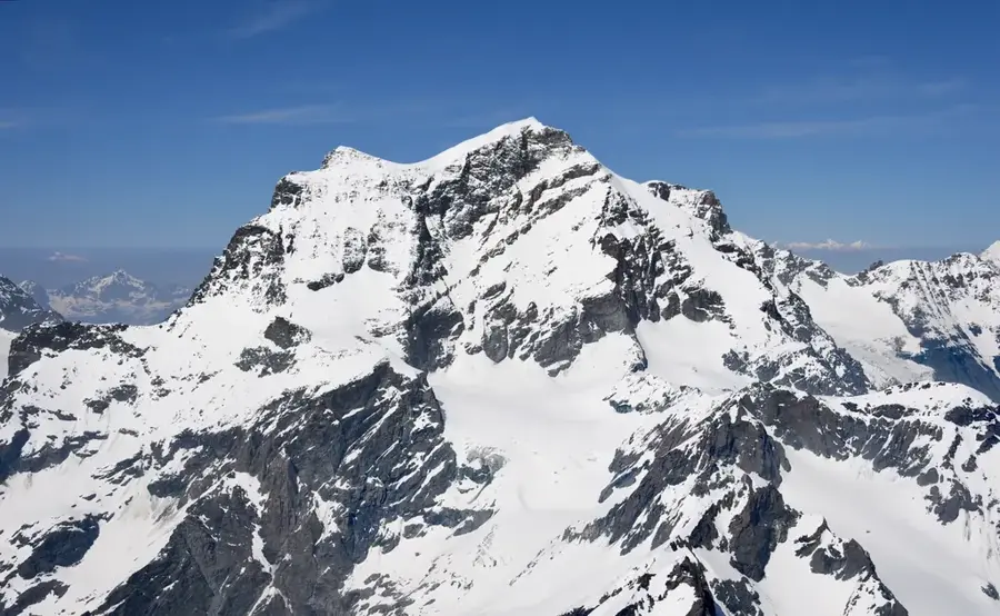
The Grand Combin is a massive mountain glaciated massif in the southwestern Pennine Alps, reaching an elevation of 4,314 meters at its highest point, the Combin de Grafeneire. The massif consists of three main summits above 4,000 meters: the aforementioned peak, the Combin de Valsorey, and the Combin de la Tsessette. Geographically, it is located between the Val de Bagnes and the Val d'Entremont, near the border with Italy. The first successful ascent of the main summit occurred in 1859 by a party led by Charles Girdlestone. The mountain is characterized by its heavy glaciation, with the Corbassière Glacier on the north side being one of the longest ice flows in the region. Due to frequent serac falls from hanging glaciers, the ascent is considered technically demanding and objectively dangerous. The Grand Combin dominates the landscape of the Lower Valais and is a significant goal for experienced mountaineers seeking high-altitude challenges in Switzerland.
- Location: Switzerland
- Top sights: Le Ritord · Beaufort · Combin de Boveire
- Nearby: Bagnes (14 km)
Best time to visit & climate
The most pleasant time to visit is Jun–Aug.
| Jan | Feb | Mar | Apr | May | Jun | Jul | Aug | Sep | Oct | Nov | Dec | |
|---|---|---|---|---|---|---|---|---|---|---|---|---|
| Avg °C | -10 | -10 | -6 | -1 | 4 | 8 | 10 | 10 | 6 | 2 | -4 | -9 |
| Rain mm | 63 | 50 | 63 | 70 | 109 | 97 | 96 | 99 | 68 | 72 | 91 | 68 |
📋 Practical info
Geography
Facts
- The elevation of the main summit, Combin de Grafeneire, is 4,314 meters.
- The first ascent of the main summit took place on July 30, 1859.
- The massif contains a total of three summits exceeding 4,000 meters.
- The Corbassière Glacier on the northern flank is nearly 10 kilometers long.
- The mountain is located entirely within the Swiss canton of Valais.
- It is one of the highest isolated massifs in the Pennine Alps.
Explore nearby
Notable places around
Route planner — Car & Motorhome
Where do you start? We build the route here, with stops and country notes along the way.
© OpenStreetMap contributors · OpenRouteService
Sights in the town Grand Combin (3)
Sights nearby
Frequently asked questions
How high is Grand Combin?
Where is this mountain located?
Why is it considered dangerous?
Which hut is used for the climb?
What is the 'Tour des Combins'?
Grand Combin: where is it located?
Grand Combin: what is there to see?
Grand Combin: when is the best time to visit?
Grand Combin: why is it worth visiting?

Nearby cities