Plizio Visual Lab
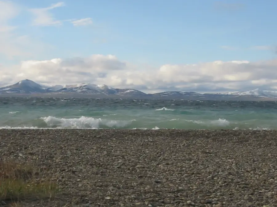
Anadyr Plateau
Weather…
Water temperature…
The Anadyr Plateau, hidden deep within the remote Chukotka region in the extreme northeast of Siberia, is an expansive, almost surreal volcanic upland. The landscape is dominated by dark, flat-topped basalt domes and mesas, the remnants of colossal prehistoric lava flows, that are now deeply incised by gorges carved by frigid, rushing rivers. This treeless, arctic expanse of shattered rock lies entirely within the continuous permafrost zone and is battered by extreme winds and unrelenting cold. It serves as the vital headwaters for the mighty Anadyr River, which winds its way across the tundra to the Bering Sea. While the punishing climate renders human settlement virtually impossible, the vast plateau acts as a critical refuge for the last remaining massive herds of wild reindeer, alongside snow sheep and arctic foxes.
Best time to visit & climate
The most pleasant time to visit is Jun–Aug.
| Jan | Feb | Mar | Apr | May | Jun | Jul | Aug | Sep | Oct | Nov | Dec | |
|---|---|---|---|---|---|---|---|---|---|---|---|---|
| Avg °C | -28 | -28 | -21 | -13 | -3 | 8 | 11 | 8 | 1 | -10 | -20 | -27 |
| Rain mm | 24 | 25 | 28 | 24 | 40 | 76 | 108 | 78 | 54 | 44 | 40 | 32 |
📋 Practical info
Geography
Route planner — Car & Motorhome
Where do you start? We build the route here, with stops and country notes along the way.
© OpenStreetMap contributors · OpenRouteService
Sights nearby
Frequently asked questions
What is the Anadyr Plateau?
Can it be visited?
How is the weather?
Is a border permit needed?
Are there accommodations there?
Anadyr Plateau: where is it located?
Anadyr Plateau: when is the best time to visit?
Anadyr Plateau: why is it worth visiting?

Nearby cities