Plizio Visual Lab
Bridge of the Americas
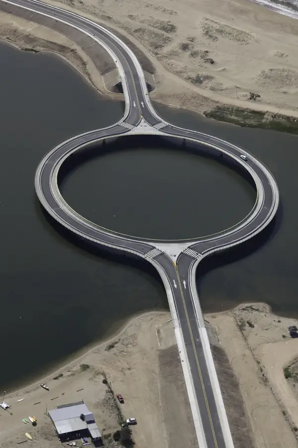
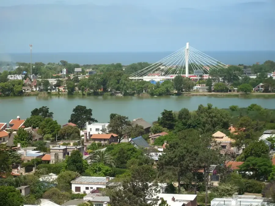
The Puente de las Américas (Bridge of the Americas) is a modern cable-stayed bridge located on the eastern outskirts of Montevideo. It was designed by the renowned Uruguayan architect Carlos Ott, the same architect who designed the Antel Tower. Inaugurated in 2005, the bridge spans the Arroyo Carrasco, which separates the departments of Montevideo and Canelones. Its primary purpose was to improve traffic flow along the coastal road, Rambla Costanera, especially for traffic heading to and from Carrasco International Airport. The bridge's design is elegant and distinctive, featuring a single, inclined pylon from which the cables that support the bridge deck extend. At night, the bridge is illuminated, making it a striking visual landmark. The Puente de las Américas is a symbol of modern Uruguay, combining functionality with sophisticated architectural aesthetics, and has quickly become a new landmark for the metropolitan area.
- Location: Uruguay
- Top sights: Galería de Arte & Subastas · MUDE - Museo Uruguayo del Escultismo · Playa Carrasco
- Nearby: Barros Blancos (8 km)
Best time to visit & climate
The most pleasant time to visit is Mar, Nov, Dec.
| Jan | Feb | Mar | Apr | May | Jun | Jul | Aug | Sep | Oct | Nov | Dec | |
|---|---|---|---|---|---|---|---|---|---|---|---|---|
| Avg °C | 23 | 23 | 21 | 18 | 15 | 12 | 10 | 12 | 13 | 16 | 19 | 21 |
| Rain mm | 102 | 106 | 118 | 114 | 84 | 98 | 92 | 89 | 96 | 103 | 96 | 86 |
📋 Practical info
Geography
Facts
- Architect: Carlos Ott
- Inaugurated: 2005
- Construction type: Cable-stayed bridge
- Location: Mouth of the Arroyo Carrasco
- Connects: Montevideo and Canelones departments
- Improves access to Carrasco International Airport
Explore nearby
Notable places around
Route planner — Car & Motorhome
Where do you start? We build the route here, with stops and country notes along the way.
© OpenStreetMap contributors · OpenRouteService
Sights in the town Bridge of the Americas (9)
Sights nearby
Frequently asked questions
Can you stop on the Puente de las Américas?
Does the bridge connect major cities?
Is there a pedestrian area?
Is it accessible for trucks?
Is the bridge closed during storms?
Bridge of the Americas: where is it located?
Bridge of the Americas: what is there to see?
Bridge of the Americas: when is the best time to visit?
Bridge of the Americas: why is it worth visiting?

Nearby cities

History & landmarks
Nature
More places