Plizio Visual Lab
Mount Syvulia
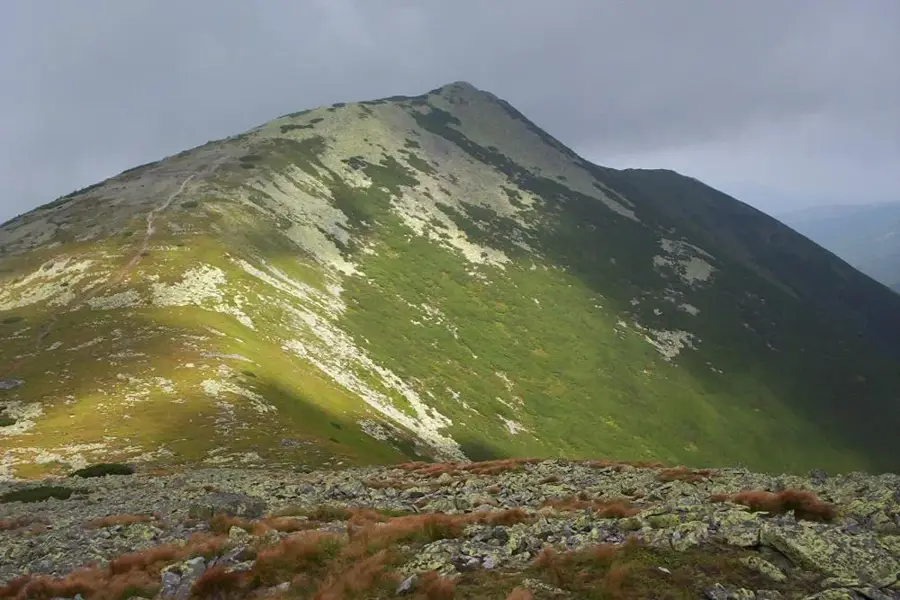
Mount Syvulia is the highest peak of the Gorgany mountain range, reaching an elevation of 1,836 meters in the Ukrainian Carpathians. It is characterized by its exceptionally steep slopes and the vast fields of grey sandstone blocks, known locally as 'gregoty', which blanker the summit area. The lower slopes are covered in dense coniferous forests, which give way to stunted mountain pine thickets at higher altitudes. Syvulia also possesses significant historical importance, having been the site of intense combat during World War I; remnants of trenches and stone fortifications are still visible today. The region is regarded as one of the most pristine and untouched parts of the Carpathians due to its rugged terrain and relative isolation. Hikers value the peak for its solitude and the raw, primeval beauty of its natural landscape. The summit provides a dramatic 360-degree panorama of neighboring ranges like Chornohora. Preserving the ecological integrity of this high-altitude ecosystem is a priority for Western Ukraine's conservation efforts.
- Location: Ukraine
- Top sights: Syvulia Velyka · Lopushna · Negrova
- Nearby: Perehinske (29 km)
Best time to visit & climate
The most pleasant time to visit is Jun–Aug.
| Jan | Feb | Mar | Apr | May | Jun | Jul | Aug | Sep | Oct | Nov | Dec | |
|---|---|---|---|---|---|---|---|---|---|---|---|---|
| Avg °C | -6 | -5 | 0 | 6 | 12 | 15 | 18 | 18 | 13 | 7 | 2 | -4 |
| Rain mm | 56 | 54 | 65 | 61 | 111 | 117 | 113 | 77 | 77 | 70 | 59 | 58 |
📋 Practical info
Geography
Facts
- Highest point in the Gorgany range at 1,836 meters.
- Famous for its extensive boulder fields called gregoty.
- Site of significant military action during World War I.
- Remnants of stone war fortifications remain visible.
- Geologically formed from resistant flysch sandstone.
- Located on the border of Ivano-Frankivsk and Zakarpattia.
Explore nearby
Notable places around
Route planner — Car & Motorhome
Where do you start? We build the route here, with stops and country notes along the way.
© OpenStreetMap contributors · OpenRouteService
Sights in the town Mount Syvulia (5)
Sights nearby
Frequently asked questions
How high is Mount Syvulia?
What are the 'greboti' on the summit?
Where does the hike start from?
Is there drinking water on the way?
How difficult is the tour?
Mount Syvulia: where is it located?
Mount Syvulia: what is there to see?
Mount Syvulia: when is the best time to visit?
Mount Syvulia: why is it worth visiting?

Nearby cities