Plizio Visual Lab
Gries Glacier
Weather…
Water temperature…
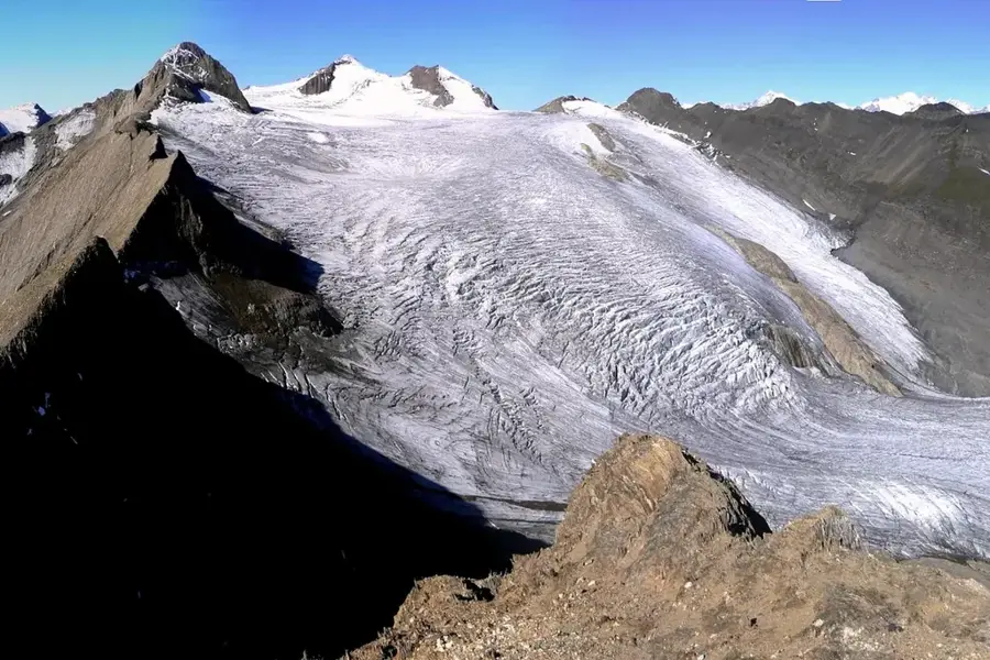
The Gries Glacier is located in the Canton of Valais within the Lepontine Alps, near the border with Ticino and Italy. It extends below the Blinnenhorn and feeds the Gries Lake, a reservoir situated at an altitude of 2386 meters, with its meltwater. In recent decades, the Gries Glacier has experienced massive retreat, making it significantly smaller today than it was in the mid-20th century. A unique feature of the region is the Gries Wind Farm, located nearby at over 2400 meters, making it one of the highest wind power facilities in Europe. The barren high-mountain landscape is characterized by gneiss rock and provides a direct view into the rapid glacial decline occurring in the Alps. Hikers often access the area via the Nufenen Pass, the highest paved mountain pass within Switzerland.
- Location: Switzerland
- Top sights: Piccolo Corno Gries · Bättelmatthorn / Punta dei Camosci · Klein Blinnenhorn
- Nearby: Aletsch Glacier (21 km)
Best time to visit & climate
The most pleasant time to visit is Jun–Aug.
| Jan | Feb | Mar | Apr | May | Jun | Jul | Aug | Sep | Oct | Nov | Dec | |
|---|---|---|---|---|---|---|---|---|---|---|---|---|
| Avg °C | -8 | -8 | -4 | 1 | 6 | 11 | 12 | 12 | 8 | 4 | -2 | -7 |
| Rain mm | 74 | 66 | 87 | 111 | 162 | 163 | 156 | 181 | 120 | 122 | 133 | 89 |
📋 Practical info
Geography
Facts
- Located below the Blinnenhorn (3374 m)
- Feeds Gries Lake at 2386 m altitude
- Gries Wind Farm stands at 2465 m
- Rapid retreat since the mid-20th century
- Accessible via the Nufenen Pass
- Geologically composed mainly of gneiss
Explore nearby
Notable places around
Route planner — Car & Motorhome
Where do you start? We build the route here, with stops and country notes along the way.
© OpenStreetMap contributors · OpenRouteService
Sights in the town Gries Glacier (4)
Sights nearby
Frequently asked questions
Where is the Gries Glacier located?
What is unique about Gries Lake?
Are there wind turbines nearby?
How do you reach the area?
Can the glacier be visited safely?
Gries Glacier: where is it located?
Gries Glacier: what is there to see?
Gries Glacier: when is the best time to visit?
Gries Glacier: why is it worth visiting?

Nearby cities