Plizio Visual Lab
Enguri Dam
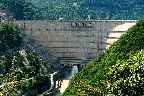
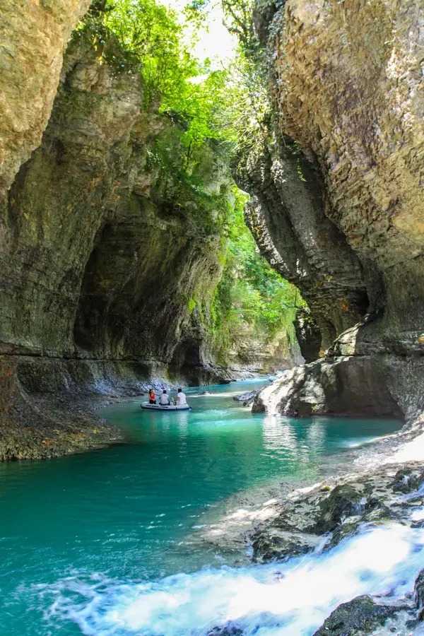
The Enguri Dam, situated on the Enguri River near the town of Jvari, is a masterpiece of Soviet-era engineering and a monumental landmark of Georgia. Standing at 271.5 meters tall, it was the highest concrete arch dam in the world at the time of its completion and currently ranks as the second-highest in this category. Construction began in 1961 and was fully completed in 1987; the facility now generates approximately 40% of Georgia's total electricity. This colossal structure creates a massive reservoir that stretches deep into the Caucasian mountain valleys. A unique political and technical aspect of the dam is its location: while the main arch dam is situated in Georgian-controlled territory, the powerhouse and generators are located in the breakaway region of Abkhazia, necessitating close cooperation between both sides to maintain power supplies. In 2015, the dam was recognized as a national cultural heritage monument, and in 2021, it was officially opened for tourism, featuring observation decks and guided tours of its internal tunnels. Its sheer scale and the surrounding lush mountain scenery make it a fascinating destination for those interested in industrial achievements and renewable energy. The Enguri Dam remains a symbol of Georgia's energy independence and human triumph over challenging terrain.
- Location: Georgia
- Top sights: Enguri dam · Valley Viewpoint · Intsira
- Nearby: Zugdidi (27 km)
Best time to visit & climate
The most pleasant time to visit is Jun–Aug.
| Jan | Feb | Mar | Apr | May | Jun | Jul | Aug | Sep | Oct | Nov | Dec | |
|---|---|---|---|---|---|---|---|---|---|---|---|---|
| Avg °C | -5 | -4 | 0 | 4 | 10 | 15 | 18 | 18 | 14 | 9 | 2 | -3 |
| Rain mm | 87 | 75 | 101 | 73 | 74 | 79 | 69 | 63 | 95 | 107 | 100 | 91 |
📋 Practical info
Geography
Facts
- At 271.5 meters, it is the second-highest concrete arch dam in the world.
- The construction of the complex lasted 26 years in total (1961 to 1987).
- The length of the dam's crest is 728 meters.
- The facility produces approximately 40% of Georgia's total electricity.
- The hydroelectric power station has an installed capacity of 1,300 megawatts.
- The reservoir has a maximum volume of approximately 1.1 billion cubic meters.
Explore nearby
Notable places around
Route planner — Car & Motorhome
Where do you start? We build the route here, with stops and country notes along the way.
© OpenStreetMap contributors · OpenRouteService
Sights in the town Enguri Dam (5)
Sights nearby
Frequently asked questions
How high is the Enguri Dam?
Can you visit the dam?
Where is the Enguri Dam located?
What role does the dam play for Georgia?
Are there leisure activities available?
Enguri Dam: where is it located?
Enguri Dam: what is there to see?
Enguri Dam: when is the best time to visit?
Enguri Dam: why is it worth visiting?

Nearby cities


History & landmarks
Nature
More places