Plizio Visual Lab
Mount Parashka
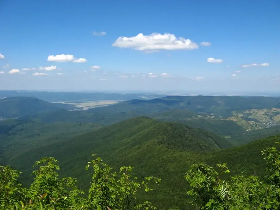
Mount Parashka is the highest peak of the Skole Beskids range in the Ukrainian Carpathians, reaching an elevation of 1,268 meters. Its name is rooted in a tragic legend dating back to 1015, which tells of the daughter of Prince Sviatoslav being killed on the slopes during a period of dynastic conflict. The summit provides some of the most spectacular panoramic views in the Lviv region and is a prominent landmark visible from a great distance on clear days. The mountain's slopes are blanketed with dense beech and coniferous forests, which are protected as part of the Skole Beskids National Nature Park. Geologically, Parashka is formed from flysch deposits, a common feature of the Outer Carpathians. The surrounding area is abundant in freshwater springs and small streams that feed into the Stryi River. Hiking routes to the top are highly popular among both locals and tourists due to the diverse and scenic terrain they traverse. Conservation of the area's biodiversity, including habitat for rare predators like lynx and wolves, is a core mission of the national park.
- Location: Ukraine
- Top sights: National Nature Park Skolivski Beskydy · Paraska · Krushelnytskyi
- Nearby: Skhidnytsia (18 km)
Best time to visit & climate
The most pleasant time to visit is Jun–Aug.
| Jan | Feb | Mar | Apr | May | Jun | Jul | Aug | Sep | Oct | Nov | Dec | |
|---|---|---|---|---|---|---|---|---|---|---|---|---|
| Avg °C | -5 | -4 | 1 | 7 | 12 | 16 | 18 | 18 | 13 | 7 | 2 | -3 |
| Rain mm | 45 | 45 | 54 | 57 | 107 | 113 | 111 | 78 | 75 | 61 | 48 | 46 |
📋 Practical info
Geography
Facts
- Highest peak of the Skole Beskids at 1,268 meters.
- Named after a legendary figure from the year 1015.
- Located within the Skole Beskids National Park.
- Provides expansive views over the Lviv region.
- Geologically formed from Carpathian flysch layers.
- Favored hiking destination starting from Skole city.
Explore nearby
Notable places around
Route planner — Car & Motorhome
Where do you start? We build the route here, with stops and country notes along the way.
© OpenStreetMap contributors · OpenRouteService
Sights in the town Mount Parashka (4)
Sights nearby
Frequently asked questions
Where is Mount Paraschka located?
How high is the mountain?
How long does the hike take?
What does the name mean?
Are there shelters?
Mount Parashka: where is it located?
Mount Parashka: what is there to see?
Mount Parashka: when is the best time to visit?
Mount Parashka: why is it worth visiting?

Nearby cities