Plizio Visual Lab
Caldera de Taburiente National Park
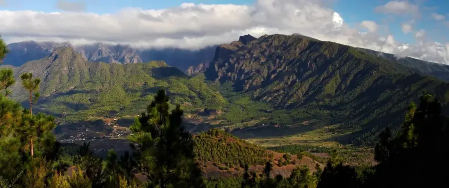
The Caldera de Taburiente National Park on the Canary Island of La Palma encompasses one of the most impressive geological formations on Earth: a gigantic erosion crater eight kilometers in diameter with sheer walls that plummet up to 2,000 meters into the depths. This rugged caldera is densely covered by resilient Canary Island pine forests, which can even survive wildfires. The rugged terrain is crisscrossed by a dense network of streams and waterfalls, most notably the famous Cascada de los Colores (Colored Waterfall), whose waters are dyed bustling shades of yellow, orange, and green by iron and mineral deposits. Perched on the highest rim of the caldera is the Roque de los Muchachos, home to one of the world's most important astrophysical observatories due to the exceptional clarity of the air.
- Location: Galicia, Spain
- Top sights: Iglesia Nuestra Senora de la Candelaria · Parque Cultural La Zarza y La Zarcita · Roque de los Muchachos
- Nearby: Santa Cruz de La Palma (11 km)
Best time to visit & climate
The most pleasant time to visit is May–Jul.
| Jan | Feb | Mar | Apr | May | Jun | Jul | Aug | Sep | Oct | Nov | Dec | |
|---|---|---|---|---|---|---|---|---|---|---|---|---|
| Avg °C | 18 | 18 | 18 | 19 | 20 | 21 | 22 | 23 | 23 | 23 | 21 | 20 |
| Rain mm | 24 | 32 | 22 | 16 | 6 | 4 | 2 | 5 | 12 | 30 | 47 | 43 |
📋 Practical info
Geography
Explore nearby
Notable places around
Route planner — Car & Motorhome
Where do you start? We build the route here, with stops and country notes along the way.
© OpenStreetMap contributors · OpenRouteService
Sights in the town Caldera de Taburiente National Park (11)
Sights nearby
Frequently asked questions
What actually is the Caldera?
What is the Roque de los Muchachos?
Are there waterfalls there?
Is hiking difficult there?
Can you camp in the park?
Caldera de Taburiente National Park: where is it located?
Caldera de Taburiente National Park: what is there to see?
Caldera de Taburiente National Park: when is the best time to visit?
Caldera de Taburiente National Park: why is it worth visiting?

Nearby cities


History & landmarks