Plizio Visual Lab

Serra da Gralheira North

Plizio editorial teamData Sources
Mountain
—°3
Serra da Gralheira North (Portugal)

Weather…

The Serra da Gralheira in northern Portugal comprises a mountain complex that includes the well-known Freita, Arada, and Montemuro ranges. The northern portion of this relief is distinguished by its rugged topography and high annual rainfall, making it one of the wettest regions in the country. Geologically, the area is characterized by metamorphic schists and granites, which have shaped a fractured landscape with deep gorges. Traditional mountain villages like Drave, now often deserted, testify to the historical adaptation of people to this isolated environment. The flora is dominated by heather and holly, while the fauna hosts rare species such as the Iberian emerald lizard. In recent decades, tourism, particularly hiking and canyoning, has grown in significance as an economic driver for the surrounding municipalities.

Best time to visit & climate

The most pleasant time to visit is Jun–Aug.

JanFebMarAprMayJunJulAugSepOctNovDec
Avg °C6791115182121191497
Rain mm13495114905833142247134137120

📋 Practical info

🧭
Getting there
Reaching this rugged northern section usually involves driving up via the regional roads connecting Cinfães and Arouca, navigating sharp bends to reach the high, exposed terrain.
📅
Best season
Late spring to early autumn provides the safest and most comfortable window for exploration, as the high ridges are notoriously prone to bitter winds and harsh conditions in winter.
⛰️
Terrain & paths
The landscape is harsh and demanding, featuring steep ascents, uneven rocky plateaus, and sparse low-lying vegetation that provides virtually no shelter from the elements.
🎒
What to bring
A high-quality windbreaker is essential year-round due to the strong gusts; solid hiking boots and layered clothing are required to cope with sudden temperature fluctuations.
🅿️
Parking
Parking options are quite limited to small, informal gravel areas beside the mountain roads, often situated near panoramic viewpoints or the sparsely distributed trailheads.
⚠️
Safety
Fierce, unpredictable crosswinds can make the exposed ridges hazardous; avoid hiking here during storms, and always stay well back from the sheer drop-offs along the edges.
⏱️
Time needed
Exploring the northern reaches of this massif is generally a demanding full-day endeavor, primarily suited for experienced hikers prepared for physical exertion and rough weather.

Geography

Coordinates
40.85000, -8.12000

Facts

  • The region records annual rainfall exceeding 2,000 mm.
  • The highest elevation in this sector is the Pico de São Pedro.
  • The deserted village of Drave is known as the region's 'magic village'.
  • The rock formations date back largely to the Paleozoic era.
  • There are significant deposits of quartz and feldspar in the area.
  • The Paiva and Vouga rivers originate within this mountain system.

Explore nearby

Notable places around

Route planner — Car & Motorhome

Where do you start? We build the route here, with stops and country notes along the way.

Vehicle
Only stops with (optional):

© OpenStreetMap contributors · OpenRouteService

Sights in the town Serra da Gralheira North (3)

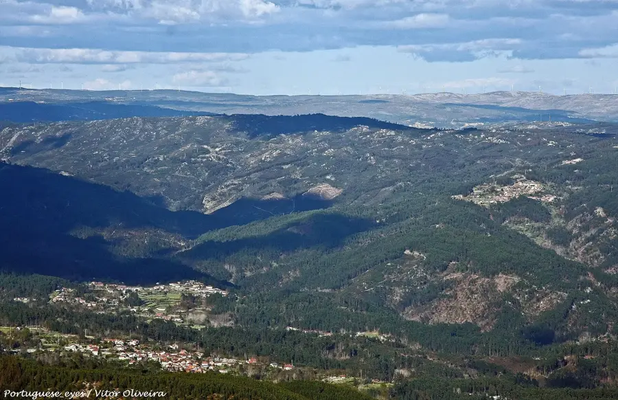
Portal do Inferno e Garra📍 landmark

A striking mountain pass and rock formation in the Serra da Arada offering dramatic landscape views.

Baloiço da Serra da Arada📍 landmark

A popular tourist swing offering panoramic views over the mountainous landscape of Serra da Arada.

Mariolas da Arada📍 landmark

Traditional stone cairns located in the mountains of Serra da Arada, often used as landmarks.

Sights nearby

Frequently asked questions

What is the best-known village in Serra da Gralheira?
Drave, a deserted 'ghost village', is a popular destination for hikers.
What leisure activities are possible there?
Hiking, canyoning, and nature photography are very popular.
Are there waterfalls nearby?
Yes, the Frecha da Mizarela is one of the highest waterfalls in Portugal.
How do you get to Serra da Gralheira?
Best by car from the towns of Arouca or São Pedro do Sul.
Is there accommodation in the mountains?
There are guest houses and rural hotels available in the surrounding villages.
Serra da Gralheira North: where is it located?
Serra da Gralheira North is located in Portugal.
Serra da Gralheira North: what is there to see?
Highlights include Portal do Inferno e Garra, Baloiço da Serra da Arada, Mariolas da Arada.
Serra da Gralheira North: when is the best time to visit?
The most pleasant time to visit is Jun, Aug.
Serra da Gralheira North: why is it worth visiting?
The Serra da Gralheira in northern Portugal comprises a mountain complex that includes the well-known Freita, Arada, and Montemuro ranges.
View on map → The Top 50 Attractions → Most beautiful beaches → OpenStreetMap →
Europe
Explore with Plizio Discover more places in Europe
More places in Portugal →

Nearby cities

History & landmarks