Plizio Visual Lab
Coast near Mahajanga
Weather…
Water temperature…
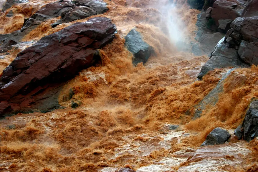
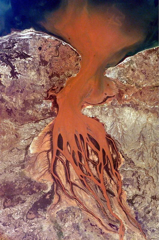
The coast near Mahajanga is located in northwestern Madagascar along the Mozambique Channel and is renowned for its striking geological formations. A central feature is the Cirque Rouge, a natural amphitheater composed of reddish-ochre sedimentary rocks shaped by erosion over millennia. The region was the power center of the Boina Kingdom in the 18th century and served as a strategic trading port for the Indian Ocean. Geographically, the coast is defined by the mouth of the Betsiboka River, whose high sediment load characteristically colors Bombetoka Bay red. Extensive mangrove forests along the shoreline provide vital habitats for numerous bird species and marine life. Today, Mahajanga is a significant economic hub and a destination for travelers who appreciate the combination of historical port structures and unique natural landscapes. Sandy beaches like Grand Pavois stretch for kilometers and are heavily influenced by the tides of the Mozambique Channel.
- Location: Madagascar
- Top sights: Village touristique · Plage du Village Touristique · Sôma Beach
- Nearby: Amborovy (5 km)
Best time to visit & climate
The most pleasant time to visit is Jun–Aug.
| Jan | Feb | Mar | Apr | May | Jun | Jul | Aug | Sep | Oct | Nov | Dec | |
|---|---|---|---|---|---|---|---|---|---|---|---|---|
| Avg °C | 28 | 28 | 28 | 28 | 27 | 25 | 25 | 25 | 26 | 27 | 28 | 28 |
| Rain mm | 470 | 281 | 204 | 70 | 18 | 15 | 18 | 11 | 11 | 27 | 108 | 225 |
📋 Practical info
Geography
Facts
- The Cirque Rouge consists of sediments that are up to 1.8 million years old.
- Mahajanga was the capital of the Boina Kingdom starting from 1745.
- Bombetoka Bay hosts approximately 46,000 hectares of mangrove forests.
- The tidal range on the coast can reach up to 4 meters.
- Fossils of predatory dinosaurs from the Cretaceous period were discovered in the region.
- The port of Mahajanga is the second most important commercial port in Madagascar.
Explore nearby
Notable places around
Route planner — Car & Motorhome
Where do you start? We build the route here, with stops and country notes along the way.
© OpenStreetMap contributors · OpenRouteService
Sights in the town Coast near Mahajanga (9)
Petite Plage
A small sandy beach with calm water, handy for relaxing.
Banja Toalaza
A theatre hosting local performances and cultural events.
Maison de la Culture
A cultural centre with exhibitions, workshops, and concerts.
Alliance Française de Mahajanga
A French cultural institute offering language courses and a library.
Porte Indo-Arabe
A historic gate recalling the Indo-Arab trade.
Sights nearby
Frequently asked questions
What is special about the coast near Mahajanga?
When is the best time for a beach visit?
Is the area family-friendly?
What is the 'Cirque Rouge'?
Are there fish restaurants in Mahajanga?
Coast near Mahajanga: where is it located?
Coast near Mahajanga: what is there to see?
Coast near Mahajanga: when is the best time to visit?
Coast near Mahajanga: why is it worth visiting?

Nearby cities

History & landmarks
Nature
More places