Plizio Visual Lab
Khorramabad
ℹ️Practical info — Khorramabad
▾
🌤 Weather — 5 days
📍 Nearby
Sights nearby
💡 Tips
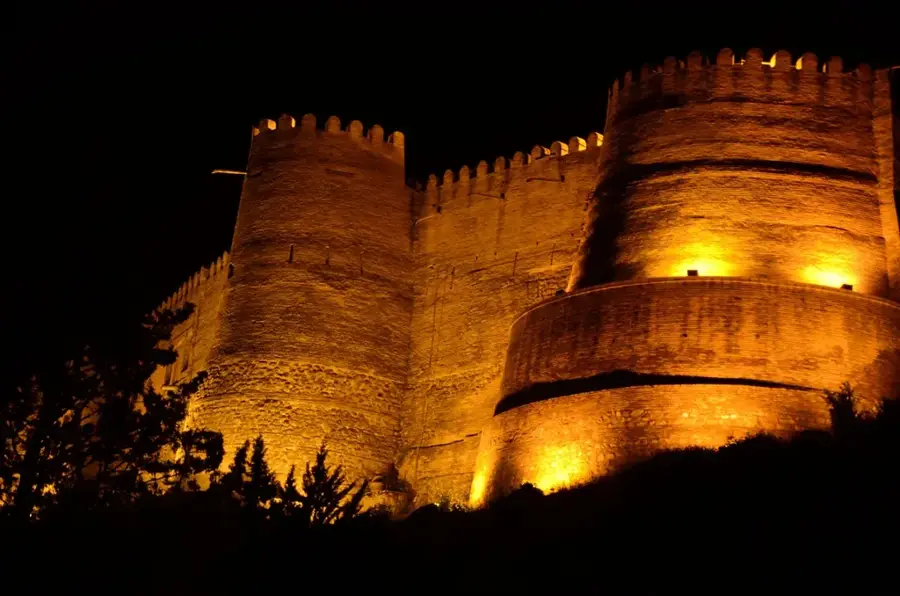
- Falak-ol-Aflak Castle is best photographed in the late afternoon when the brickwork glows in the sun.
- Taxis around the city are cheap, but always agree on the fare before getting in if there's no meter.
- Dress modestly and respect local customs, especially when visiting the bazaars and religious sites.
- Try to learn a few basic Persian phrases; locals are extremely welcoming and appreciate the effort.
🍽 Food
A staple of Iranian cuisine, widely available in traditional restaurants around the castle area.
A sour yogurt soup with herbs and chickpeas, excellent for cooler evenings in the Zagros mountains.
Buy freshly baked Sangak or Lavash from local bakeries early in the morning.
🛍 Shopping · 🧘 Quiet spots
A great place to find local spices, nuts, and traditional Lorestan carpets.
Look for intricately designed copper plates and pots in the older sections of the market.
A natural lake in the northwest of the city, handy for a peaceful evening stroll.
The 'Velvet Mountain' provides scenic, quiet hiking trails just outside the city.
Water temperature…
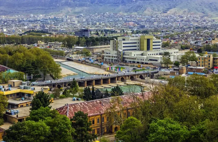
Khorramabad, the strategic capital of Lorestan Province in western Iran, is positioned within the scenic valleys of the Central Zagros Mountains at an elevation of 1,147 meters. The city’s history is ancient, with roots stretching back to the Elamite civilization, when it was known as Khaidalu. Its most iconic landmark is the Falak-ol-Aflak Castle, a massive Sassanid-era fortress with eight towers that overlooks the city center and houses a rich ethnographic museum. Khorramabad is characterized by its abundant water sources, including the Khorramabad River and the natural Keio Lake, which serves as a major recreational hub for residents. The population is predominantly Luri, and the city is a central point for Luri culture, famous for its distinctive music, nomadic heritage, and traditional attire. Economically, Khorramabad thrives on agriculture, livestock, and stone quarrying industries, being one of the leading regions in Iran for high-quality construction stones. The climate is Mediterranean-influenced, featuring hot summers and relatively cold, wet winters, making the surrounding landscapes lush and verdant during the spring. In recent years, the city has seen significant infrastructural growth, particularly with its connection to the Tehran-Bandar Imam Khomeini expressway and the expansion of its regional airport. Tourism is a growing sector, driven by the proximity to wide-open natural sites like the Bisheh and Gherit waterfalls and the prehistoric cave paintings in the nearby mountains. The city also hosts the Lorestan University of Medical Sciences and the University of Lorestan, contributing to its status as a regional educational center. Khorramabad remains a vital link between the Iranian plateau and the Mesopotamian lowlands, blending its historical grandeur with the animated daily life of the Luri people.
- Location: Iran
- Top sights: Gerdab-e Sangi · Besat Mosque · Ayatollah Kamalvand Mosque
- Nearby: Dezful (82 km)
- Population: ~329.825 (2024)
Best time to visit & climate
The most pleasant time to visit is May, Jun, Sep.
| Jan | Feb | Mar | Apr | May | Jun | Jul | Aug | Sep | Oct | Nov | Dec | |
|---|---|---|---|---|---|---|---|---|---|---|---|---|
| Avg °C | 1 | 2 | 7 | 12 | 18 | 25 | 28 | 27 | 23 | 16 | 7 | 3 |
| Rain mm | 47 | 36 | 52 | 61 | 19 | 5 | 1 | 0 | 2 | 24 | 46 | 56 |
Geography
Facts
- Falak-ol-Aflak Castle covers an area of approximately 5,300 square meters on top of a hill.
- The city's population was recorded at 373,416 during the 2016 national census.
- Khorramabad serves as the administrative center for 11 counties within Lorestan Province.
- The Keio Lake is fed by several underground springs originating from the Zagros Mountains.
- The historical 'Broken Bridge' (Shapuri Bridge) dates back to the Sassanid era.
- The city experiences an average annual temperature of about 17.2 degrees Celsius.
- It is located on the main transit route connecting the Persian Gulf to central Iran.
- The nearby Bisheh Waterfall is 48 meters high and is a designated national heritage site.
Explore nearby
Notable places around
Route planner — Car & Motorhome
Where do you start? We build the route here, with stops and country notes along the way.
© OpenStreetMap contributors · OpenRouteService
Sights in the town Khorramabad (3)
Frequently asked questions
What is the landmark of Chorramabad?
Are there waterfalls near Chorramabad?
Which people mainly live in Chorramabad?
What is the nature like in the surroundings?
Are there ancient sites in Chorramabad?
Khorramabad: where is it located?
Khorramabad: what is there to see?
Khorramabad: when is the best time to visit?
Khorramabad: why is it worth visiting?