Plizio Visual Lab

Mols Bjerge National Park

Plizio editorial teamData Sources
park
—°4
Mols Bjerge National Park (Denmark)

Weather…

Mols Bjerge National Park is situated on the Djursland peninsula in Jutland, encompassing a diverse landscape of approximately 180 square kilometers. The heart of the park is the namesake Mols Hills, a range formed during the last ice age by the movement of massive glaciers. Its highest point, Agri Baunehøj, stands at 137 meters and provides dramatic panoramic views over Aarhus Bay and the Kattegat sea. In addition to the rolling hills, the protected area includes coastal stretches, bogs, and dense forests that serve as habitats for rare insects and specialized plant species. A significant historical landmark within the park is the Kalø Castle ruin, which dates back to the 14th century and is connected to the mainland by a medieval stone causeway. The national park was officially established in 2009 to integrate environmental conservation with the preservation of cultural heritage. Extensive hiking trails and scenic viewpoints make the area one of the most popular recreational destinations in Central Denmark. The geological variety and historical depth of Mols Bjerge make it a unique testament to Denmark's natural and human history.

Best time to visit & climate

The most pleasant time to visit is Jul–Sep.

JanFebMarAprMayJunJulAugSepOctNovDec
Avg °C223711151718151174
Rain mm604843395171788364797065

📋 Practical info

🧭
Getting there
The national park is broadly accessible via the surrounding regional road network in East Jutland, with multiple signposted gateways welcoming visitors from nearby towns and municipalities.
📅
Best season
The warmer months of summer provide the most reliable weather for exploring the expansive coastal stretches, while spring beautifully highlights the blooming pastures and forest canopies.
⛰️
Terrain & paths
Expect a remarkable diversity ranging from undulating ice-age moraines and open grazing lands to sandy beaches, requiring varied physical effort depending on the chosen route.
🎒
What to bring
Durable footwear suited for both sandy shores and steep, grassy inclines is essential, along with sufficient water supplies and reliable protection against sudden coastal winds.
🅿️
Parking
Comprehensive parking facilities are distributed throughout the park, commonly located near main attractions, scenic viewpoints, and the trailheads leading into the hilly interior.
⚠️
Safety
Standard hiking precautions apply; visitors should strictly observe weather forecasts, stick to officially designated paths, and exercise care around grazing livestock in pasture zones.
⏱️
Time needed
Exploring the contrasting landscapes of this national park easily commands anywhere from a half-day excursion to a full-day adventure, depending on individual stamina and interests.

Geography

Coordinates
56.23000, 10.55000

Facts

  • The national park was officially opened on August 29, 2009.
  • Agri Baunehøj is the highest point in the park at 137 meters above sea level.
  • The Kalø Castle ruin was built around 1313 by King Erik Menved.
  • The area is home to approximately 40 of Denmark's 60 butterfly species.
  • The park covers a land area of roughly 18,000 hectares.
  • The hilly landscape was created by glacial activity about 12,000 years ago.

Explore nearby

Notable places around

Route planner — Car & Motorhome

Where do you start? We build the route here, with stops and country notes along the way.

Vehicle
Only stops with (optional):

© OpenStreetMap contributors · OpenRouteService

Sights in the town Mols Bjerge National Park (4)

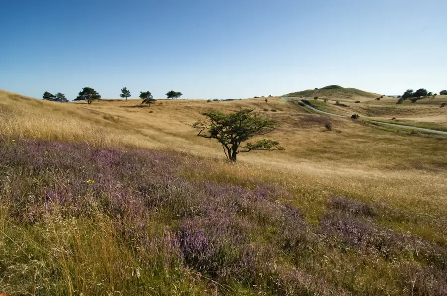
Femmøller Strand🎡 recreation

Surrounded by the remarkable landscapes of Mols Bjerge National Park, Femmøller Strand is a breath of fresh coastal air. The wild and natural mood of the area creates an authentic, undisturbed sanctuary for outdoor enthusiasts. Visitors can easily plunge into the brisk water, rest on the pristine sands, or hike the nearby scenic trails. It is a handy spot to witness nature's beauty while enjoying a coastal escape.

Agri Bavnehøj🏺 historical

One of the highest bronze age burial mounds in the Mols Bjerge National Park.

Rishøj🏺 historical

Prehistoric burial site located within the national park.

Grøftebjerghøj🏺 historical

A historic burial mound and archaeological site in Mols Bjerge.

Sights nearby

Frequently asked questions

What are the highlights of Mols Bjerge?
The hilly ice-age landscape, the ruins of Kalø Castle, and the photogenic town of Ebeltoft.
How difficult are the hiking trails?
There are trails for all levels; some sections are quite steep but offer great views of the Baltic Sea.
Where is the best place to park?
Visitor centers like Øvre Strandkær or the parking lot at the Kalø ruins are good starting points.
Are there guided tours in the park?
Yes, rangers and the visitor center regularly offer themed hikes on nature and history.
When is the best time to visit?
Spring and autumn are well-suited for hiking; summer is great for trips to the nearby beaches.
Mols Bjerge National Park: where is it located?
Mols Bjerge National Park is located in Denmark.
Mols Bjerge National Park: what is there to see?
Highlights include Femmøller Strand, Agri Bavnehøj, Rishøj.
Mols Bjerge National Park: when is the best time to visit?
The most pleasant time to visit is Jul, Sep.
Mols Bjerge National Park: why is it worth visiting?
Mols Bjerge National Park is situated on the Djursland peninsula in Jutland, encompassing a diverse landscape of approximately 180 square kilometers.
View on map → The Top 50 Attractions → Most beautiful beaches → OpenStreetMap →
Europe
Explore with Plizio Discover more places in Europe
More places in Denmark →

Nearby cities

History & landmarks

More places