Plizio Visual Lab
Serak
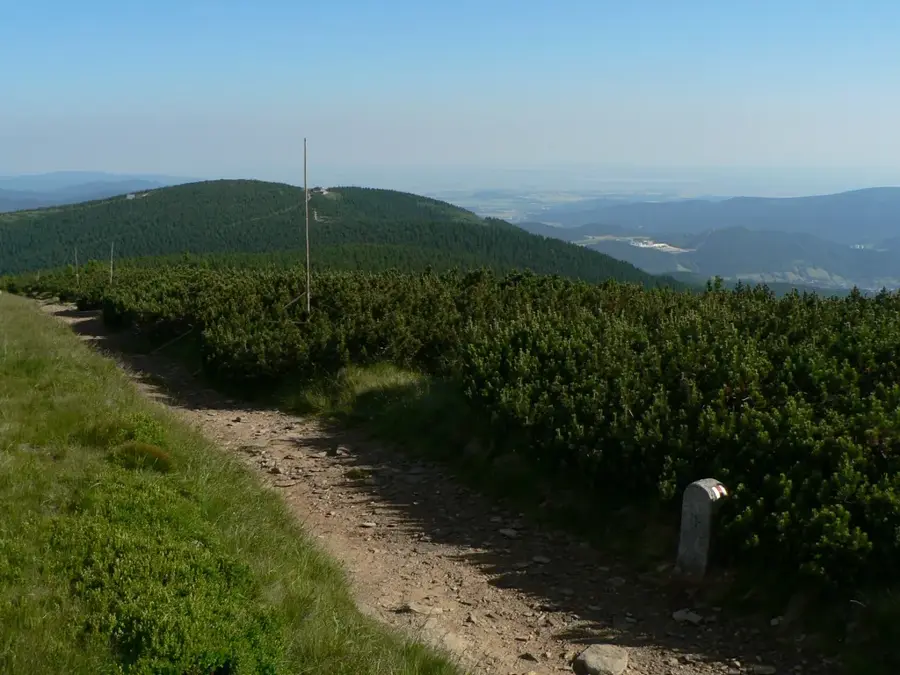
Šerák is a prominent peak in the Hrubý Jeseník range, standing at 1351 meters and forming the northern anchor of the mountain's main ridge. The mountain is renowned for the 'Chata Jiřího na Šeráku' mountain hut, built in 1888, which is one of the oldest and most beloved alpine lodges in Moravia. Geologically, Šerák is composed mainly of gneiss and crystalline schists, with its summit area featuring striking rock outcrops and stone runs. Since 1955, much of the mountain has been part of a national nature reserve established to protect its valuable alpine flora and original spruce forests. A major feature of local tourism is the chairlift from Ramzová, which brings visitors directly to the ridge just below the summit. The views from the top are exceptional, encompassing the Silesian lowlands in Poland, the Glatze mountains, and the nearby Praděd, the highest peak of Moravia. The area is characterized by a harsh alpine climate, making it a key destination for skiing and snowshoeing in winter. In summer, the hut serves as a vital crossroads for long-distance hiking trails that traverse the entire Jeseníky range.
- Location: Czech Republic
- Top sights: Šerák · Koňská vyhlídka · NPR Šerák-Keprník
- Nearby: Jeseník (8 km)
Best time to visit & climate
The most pleasant time to visit is Jun–Aug.
| Jan | Feb | Mar | Apr | May | Jun | Jul | Aug | Sep | Oct | Nov | Dec | |
|---|---|---|---|---|---|---|---|---|---|---|---|---|
| Avg °C | -4 | -2 | 2 | 8 | 12 | 17 | 19 | 18 | 13 | 8 | 3 | -2 |
| Rain mm | 47 | 40 | 45 | 42 | 78 | 82 | 85 | 77 | 63 | 51 | 45 | 44 |
📋 Practical info
Geography
Facts
- Šerák stands at 1351 meters above sea level in the High Jeseník mountains.
- The Jiřího mountain hut was built in 1888 by the Moravian-Silesian Hiking Society.
- A two-stage chairlift connects the village of Ramzová to the summit ridge.
- The peak is a part of the Šerák-Keprník National Nature Reserve, founded in 1955.
- The mountain features massive boulder fields created by periglacial processes.
- The view to the north extends across the border into the Polish region of Nysa.
Explore nearby
Notable places around
Route planner — Car & Motorhome
Where do you start? We build the route here, with stops and country notes along the way.
© OpenStreetMap contributors · OpenRouteService
Sights in the town Serak (7)
Obří skály
Massive rock formation, a 10-16 m high frost cliff, a prominent landmark.
Skalní vyhlídka
Natural lookout point on a rock formation.
PR Šumárník
Protected nature reserve with valuable habitats.
Keprník
Mountain in the Czech Republic, part of the mountain range.
Sights nearby
Frequently asked questions
How to get to Šerák?
Is there accommodation on the mountain?
Is Šerák also a ski resort?
What is the natural specialty here?
Can you hike to Praděd from here?
Serak: where is it located?
Serak: what is there to see?
Serak: when is the best time to visit?
Serak: why is it worth visiting?

Nearby cities