Plizio Visual Lab
Boco
Weather…
Water temperature…
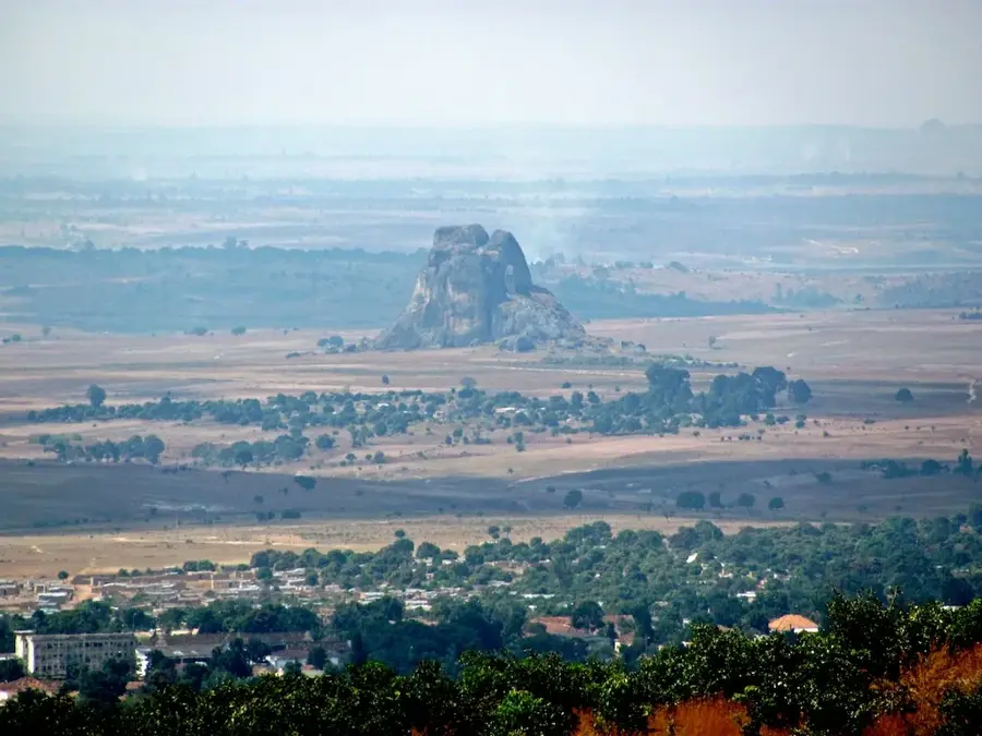
Monte Boco is a prominent mountain in the central highlands of Angola, located in the Benguela province. It is part of the plateau that dominates the region, serving as a natural divide between the coastal plains and the interior highlands. Geographically, Monte Boco is characterized by its rugged granite formations and steep slopes, which are typical of the central plateau's geology. The region surrounding the mountain, particularly the Bocoio district, is known for its agricultural significance, where the temperate highland climate favors the cultivation of various crops. Historically, the area was an important settlement space for the Ovimbundu people, who farmed the fertile valleys at the foot of the mountain. The vegetation on Monte Boco consists primarily of Miombo woodlands and alpine grasses at higher elevations. The mountain provides spectacular panoramic views over the surrounding rolling hills and serves as a vital watershed for local streams. Despite its natural beauty, the mountain remains largely undeveloped for tourism, making it a lesser-known spot for nature enthusiasts.
- Location: Angola
- Nearby: Caála (63 km)
Best time to visit & climate
The most pleasant time to visit is May, Aug, Sep.
| Jan | Feb | Mar | Apr | May | Jun | Jul | Aug | Sep | Oct | Nov | Dec | |
|---|---|---|---|---|---|---|---|---|---|---|---|---|
| Avg °C | 20 | 20 | 20 | 20 | 19 | 17 | 17 | 20 | 22 | 22 | 21 | 20 |
| Rain mm | 187 | 169 | 245 | 83 | 8 | 1 | 0 | 4 | 33 | 101 | 265 | 201 |
📋 Practical info
Geography
Facts
- The mountain is located in Benguela Province near Bocoio.
- The summit elevation reaches approximately 1,800 meters.
- The geology is defined by massive granite rock formations.
- The region is a traditional settlement area for the Ovimbundu.
- Miombo woodlands dominate the natural slope vegetation.
- Annual rainfall is significantly higher than in the coastal lowlands.
Explore nearby
Notable places around
Route planner — Car & Motorhome
Where do you start? We build the route here, with stops and country notes along the way.
© OpenStreetMap contributors · OpenRouteService
Sights in the town Boco (1)
Sights nearby
Frequently asked questions
How hard is it to climb Boco?
When should you visit Boco?
Is a guide useful on Boco?
Are there accommodation or camping options on the mountain?
Is Boco good for landscape photography?
Boco: where is it located?
Boco: when is the best time to visit?
Boco: why is it worth visiting?

Nearby cities

History & landmarks
More places