Plizio Visual Lab
Wilhelmina Mountains

Weather…
Water temperature…
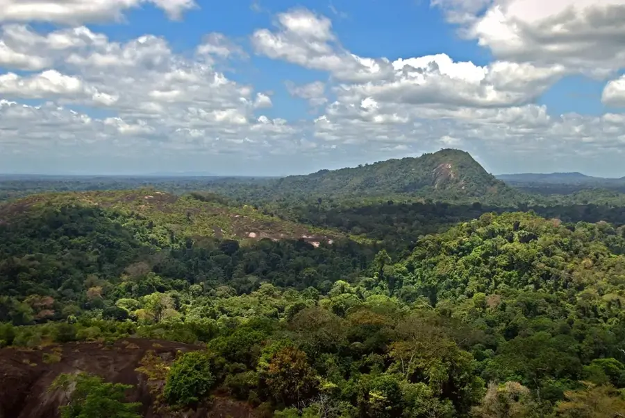
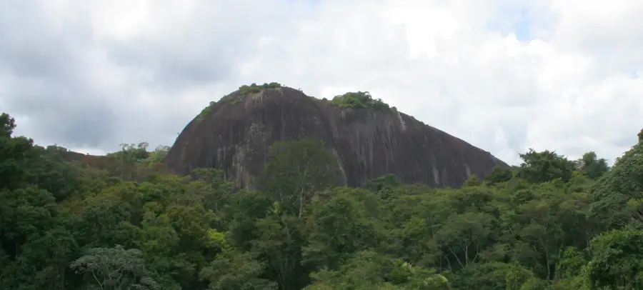
The Wilhelmina Mountains are the most significant mountain range in Suriname, stretching for about 113 kilometers in the central Sipaliwini District. The range contains Julianatop, the highest point in the country at 1,230 meters above sea level. Named after Queen Wilhelmina of the Netherlands, the mountains form a central part of the ancient Guiana Shield. The region is almost entirely covered by pristine tropical rainforest and, due to its extreme remoteness, remains one of the least explored areas in South America. Many of Suriname's major rivers, including the Coppename and Lucie, have their headwaters in these mountains. Geologically, the range is composed primarily of ancient igneous and metamorphic rocks. High humidity and heavy rainfall in the upper elevations support a unique cloud forest flora with many endemic species. The mountains serve as a vital watershed and are a cornerstone of Suriname's interior conservation efforts.
Best time to visit & climate
The most pleasant time to visit is Sep–Nov.
| Jan | Feb | Mar | Apr | May | Jun | Jul | Aug | Sep | Oct | Nov | Dec | |
|---|---|---|---|---|---|---|---|---|---|---|---|---|
| Avg °C | 25 | 25 | 25 | 25 | 25 | 24 | 24 | 25 | 26 | 27 | 27 | 26 |
| Rain mm | 142 | 155 | 168 | 235 | 308 | 254 | 193 | 122 | 56 | 55 | 69 | 150 |
📋 Practical info
Geography
Facts
- Home to Julianatop, Suriname's highest peak (1,230 m).
- The mountain range spans roughly 113 kilometers.
- Named in honor of Queen Wilhelmina of the Netherlands.
- Located within the central Sipaliwini District.
- Headwaters for the Coppename and Lucie rivers.
- Consists of ancient rocks of the Guiana Shield.
Explore nearby
Notable places around
Route planner — Car & Motorhome
Where do you start? We build the route here, with stops and country notes along the way.
© OpenStreetMap contributors · OpenRouteService
Sights nearby
Frequently asked questions
Are the mountains developed?
What is the altitude of the mountains?
Are there guided expeditions?
What is the weather like there?
Why go there?
Wilhelmina Mountains: where is it located?
Wilhelmina Mountains: when is the best time to visit?
Wilhelmina Mountains: why is it worth visiting?

History & landmarks
Nature
More places