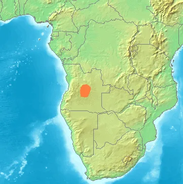
Plizio Visual Lab

Lunda Mountains

Plizio editorial teamData Sources
Mountain
—°
Lunda Mountains (Angola)

Weather…

The Lunda Mountains in northeastern Angola form an extensive upland plateau that serves as a critical watershed between the Congo and Zambezi river basins. This region is geologically renowned for its vast deposits of alluvial diamonds, which have been a primary driver of the local economy for over a century. The landscape is defined by rolling hills, expansive plateaus, and deep river valleys lined with dense gallery forests that support a variety of wildlife. Historically, the Lunda highlands were the heart of the Lunda Empire, a powerful political entity that dominated central African trade routes during the 17th and 18th centuries. The tropical climate brings heavy seasonal rains, feeding major rivers such as the Kasai and Kwango at their sources. Today, the Lunda region remains essential to Angola's mining sector, while efforts continue to balance industrial development with the preservation of the Lunda people's rich cultural heritage and traditional governance structures.

Best time to visit & climate

The most pleasant time to visit is May–Jul.

JanFebMarAprMayJunJulAugSepOctNovDec
Avg °C222323232423242525242222
Rain mm1151181597914202494148189150

📋 Practical info

🧭
Getting there
Reaching this remote northeastern hilly landscape requires navigating regional overland routes that often originate from provincial capitals. Travelers generally need a dependable four-wheel-drive vehicle due to the lack of fully paved modern roadways.
📅
Best season
The region is usually best explored during the cooler dry season, which broadly falls between May and September. Venturing here during the heavy rainy season can turn unpaved dirt tracks into impassable mud, significantly complicating overland travel.
⛰️
Terrain & paths
The geography features an undulating topography with varying elevations, rugged hills, and scattered vegetation. Trail systems are largely undeveloped, meaning visitors will encounter rough, natural ground that requires careful navigation on foot.
🎒
What to bring
Self-sufficiency is critical in this remote area; visitors must carry substantial reserves of food, clean drinking water, and emergency medical supplies. Sturdy hiking boots and reliable GPS navigation tools are also considered mandatory.
🅿️
Parking
There are virtually no structured parking facilities within the wilderness of these remote mountains. Vehicles are essentially parked off the main tracks at makeshift campsites or near small local rural settlements, minimizing environmental impact.
⚠️
Safety
The immense isolation of the terrain poses the most significant risk, making it vital to travel in accompanied convoys or with local guides. Medical facilities are extremely distant, so avoiding reckless behavior and carrying first-aid kits is paramount.
⏱️
Time needed
Reaching and briefly exploring the edges of this hilly topography usually requires a multi-day overland commitment. Due to the challenging logistics and vast distances, most visitors set aside at least three to five full days to properly experience it.

Geography

Coordinates
-8.00000, 19.00000

Facts

  • The Lunda region accounts for approximately 90% of Angola's diamond production.
  • The highlands sit at an average elevation between 1,000 and 1,300 meters above sea level.
  • The Lunda Empire at its peak spanned parts of modern-day Angola, Zambia, and DR Congo.
  • The Kasai River, a major tributary of the Congo River, originates in these mountains.
  • Average annual precipitation in the Lunda highlands is around 1,400 millimeters.
  • The first commercial diamond discovery in the region was made in 1912.

Explore nearby

Notable places around

Route planner — Car & Motorhome

Where do you start? We build the route here, with stops and country notes along the way.

Vehicle
Only stops with (optional):

© OpenStreetMap contributors · OpenRouteService

Sights nearby

Frequently asked questions

What are the Lunda Mountains?
A mountain and hill region in the northeast with a quiet, rural character. It is scenic and not very crowded with tourists.
When should you travel to the Lunda Mountains?
The dry season is best because roads are more passable. For clear views, morning hours are especially good.
Is the area suitable for hiking?
Yes, especially for easy to moderate hikes and viewpoints. Longer trips need planning and water.
Are there villages or markets there?
Yes, usually small settlements with local life. Markets can be good for regional products and local contact.
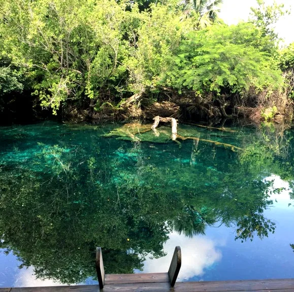
Is the scenery beautiful?
Yes, with ridge lines, distant views, and changing light. It is a quiet, expansive landscape.
Lunda Mountains: where is it located?
Lunda Mountains is located in Angola.
Lunda Mountains: when is the best time to visit?
The most pleasant time to visit is May, Jul.
Lunda Mountains: why is it worth visiting?
The Lunda Mountains in northeastern Angola form an extensive upland plateau that serves as a critical watershed between the Congo and Zambezi river basins.
View on map → The Top 50 Attractions → OpenStreetMap →
Africa
Explore with Plizio Discover more places in Africa
More places in Angola →

Nearby cities

Nature

More places