Plizio Visual Lab
Cunene Valley
Weather…
Water temperature…
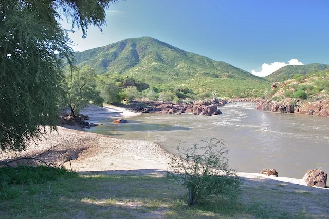
The Cunene Valley in southern Angola serves as the natural and political border with Namibia, representing one of the most arid yet geographically impressive regions of the country. The Cunene River carves a dramatic path toward the Atlantic Ocean, featuring world-renowned landmarks such as the Ruacana and Epupa Falls, which drop into deep rocky chasms. Geologically, the valley is shaped by the river's erosion through ancient limestone and volcanic rock, creating a landscape of stark contrasts and deep gorges. Historically, the region has been inhabited by the Himba and Herero pastoralists, who have maintained their traditional semi-nomadic lifestyles despite the harsh climatic conditions. The semiarid climate makes the river an essential lifeline for both wildlife and local communities in an otherwise desert environment. Today, the Cunene Valley is a vital site for joint hydroelectric power generation between Angola and Namibia and remains a focal point for transboundary ecological conservation efforts.
- Location: Angola
- Nearby: Curoca (33 km)
Best time to visit & climate
The most pleasant time to visit is May, Jul, Aug.
| Jan | Feb | Mar | Apr | May | Jun | Jul | Aug | Sep | Oct | Nov | Dec | |
|---|---|---|---|---|---|---|---|---|---|---|---|---|
| Avg °C | 23 | 23 | 23 | 23 | 22 | 20 | 20 | 22 | 24 | 26 | 25 | 24 |
| Rain mm | 106 | 108 | 170 | 40 | 3 | 0 | 0 | 0 | 2 | 15 | 86 | 74 |
📋 Practical info
Geography
Facts
- The Cunene River extends for a total length of approximately 1,050 kilometers.
- Ruacana Falls stand 120 meters high and span 700 meters in width.
- The Epupa Falls consist of a series of over 20 distinct cascading waterfalls.
- The Calueque Dam project in the valley was a significant flashpoint during the Angolan Civil War.
- Average annual rainfall in the lower Cunene Valley is less than 250 millimeters.
- The Cunene River supports a large and healthy population of Nile crocodiles.
Explore nearby
Notable places around
Route planner — Car & Motorhome
Where do you start? We build the route here, with stops and country notes along the way.
© OpenStreetMap contributors · OpenRouteService
Sights nearby
Frequently asked questions
What defines the Cunene Valley?
When should you travel to the Cunene Valley?
Is the region suitable for camping?
Are there good photo spots by the river?
Is the Cunene Valley family-friendly?
Cunene Valley: where is it located?
Cunene Valley: when is the best time to visit?
Cunene Valley: why is it worth visiting?