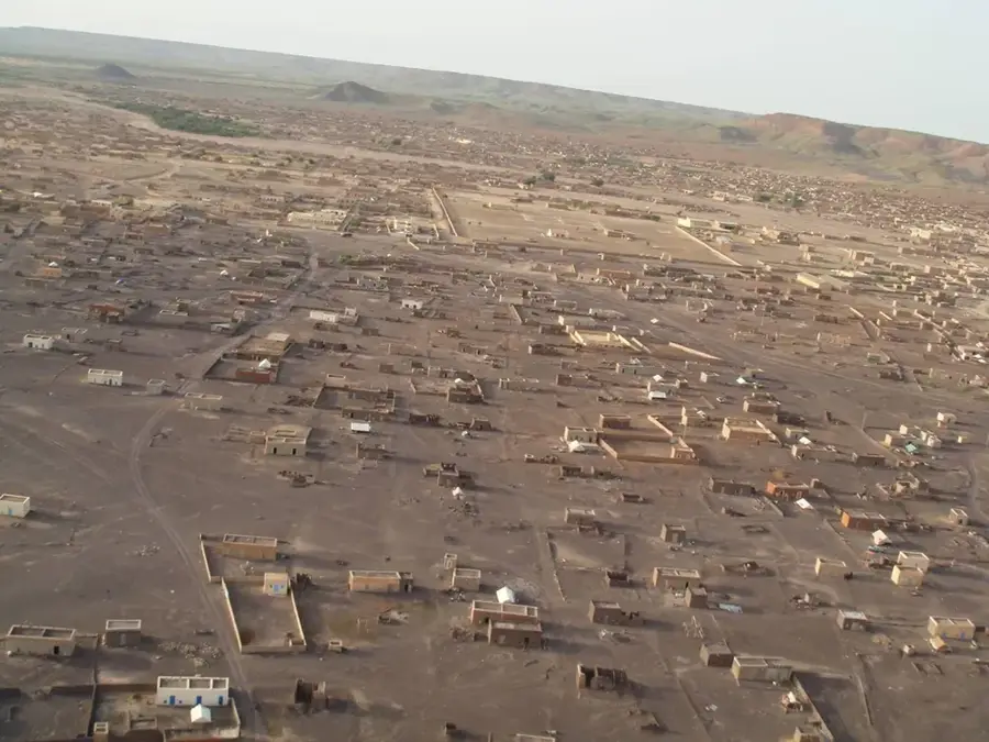
Plizio Visual Lab

Dhar Nema

Plizio editorial teamData Sources
Mountain
—°
Dhar Nema (Mauritania)

Weather…

Dhar Nema is a prominent sandstone cliff formation located in southeastern Mauritania, near the town of Néma in the Hodh Ech Chargui region. This striking geological ridge extends for several kilometers, creating a dramatic edge to the elevated plateau. From the top of the cliff, one is treated to a vast panoramic view of the surrounding savanna and arid plains that stretch toward the border with Mali. Positioned in the transition zone between the Sahara Desert and the Sahel, the area supports a specialized ecosystem of flora and fauna adapted to the harsh, dry climate. Historically, Dhar Nema served as a vital landmark for caravans traversing the ancient trans-Saharan trade routes. The cliff faces display fascinating erosion patterns carved by centuries of wind and occasional intense rainfall. For those exploring the remote reaches of Mauritania, Dhar Nema gives an unforgettable example of the raw, untouched beauty of the country's interior highlands.

Best time to visit & climate

The most pleasant time to visit is Jan, Feb, Dec.

JanFebMarAprMayJunJulAugSepOctNovDec
Avg °C202327313435322929292521
Rain mm01119218313765800

📋 Practical info

🧭
Getting there
Reaching the prominent cliff edge generally involves navigating unpaved, rough dirt tracks in the southeastern region with a sturdy 4x4 vehicle. Employing a local driver or guide who knows the remote savanna routes is highly advised for a successful and safe journey.
📅
Best season
The optimal visiting window typically spans the cooler months from November to February, avoiding the intense heat of the peak summer season. Traveling just after the rainy season might offer slightly greener savanna landscapes, though roads can be much more challenging.
⛰️
Terrain & paths
The hike to the best viewpoints demands walking over uneven, rocky ground and navigating steep, unmaintained paths near the cliff's edge. Visitors must be prepared for a rugged, natural environment devoid of paved walkways, requiring a solid sense of balance and care.
🎒
What to bring
Sturdy trekking boots with excellent ankle support are essential for safely handling the rocky and potentially unstable surfaces near the drop-offs. Given the wide-open savanna exposure, bringing a broad hat, high-quality sunglasses, and ample drinking water is mandatory.
🅿️
Parking
Finding a designated parking area is unlikely; instead, visitors usually leave their robust vehicles at an informal, safe distance from the cliff. It is crucial to ensure the car is parked on solid, flat ground to avoid getting stuck in loose dirt or mud before hiking.
⚠️
Safety
Extreme caution is required when standing near the sheer cliff edges, as strong winds and unstable rocky overhangs can present significant falling hazards. Always maintain a safe distance from the precipice and remain vigilant regarding sudden changes in the local weather.
⏱️
Time needed
A typical excursion to enjoy the panoramic savanna views and explore the immediate rocky surroundings lasts around two to three solid hours. Photographers and nature enthusiasts might extend their stay to a full half-day to capture the shifting light across the landscape.

Geography

Coordinates
16.60000, -7.20000

Facts

  • Nema is the capital of the Hodh Ech Chargui region at the foot of the Dhar.
  • The escarpment forms a significant watershed in this arid region.
  • The ruins of Kumbi Saleh, the ancient Ghana Empire capital, are nearby.
  • The sandstone layers date back to the Paleozoic era.
  • It is a key sanctuary area for nomads during the dry season.
  • The Dhar rises approximately 100 to 150 meters above the surrounding plain.

Explore nearby

Notable places around

Route planner — Car & Motorhome

Where do you start? We build the route here, with stops and country notes along the way.

Vehicle
Only stops with (optional):

© OpenStreetMap contributors · OpenRouteService

Sights nearby

Frequently asked questions

What is Dhar Nema?
A prominent escarpment marking a geological boundary in the desert.
Can one climb the escarpment?
Only with experienced company and the right equipment.
How is the light for photography?
Spectacular during the golden hour just before sunset.
Are there shelters there?
No, complete self-sufficiency and camping are necessary.
What is the biggest danger?
Navigation loss and the extreme heat during the day.
Dhar Nema: where is it located?
Dhar Nema is located in Mauritania.
Dhar Nema: when is the best time to visit?
The most pleasant time to visit is Jan, Feb, Dec.
Dhar Nema: why is it worth visiting?
Dhar Nema is a prominent sandstone cliff formation located in southeastern Mauritania, near the town of Néma in the Hodh Ech Chargui region.
View on map → The Top 50 Attractions → OpenStreetMap →
Africa
Explore with Plizio Discover more places in Africa
More places in Mauritania →

Nearby cities

History & landmarks

More places