Plizio Visual Lab
Kut
ℹ️Practical info — Kut
▾
🌤 Weather — 5 days
📍 Nearby
Sights nearby
💡 Tips
- Visit the banks of the Tigris River early in the morning or late evening to avoid the heat.
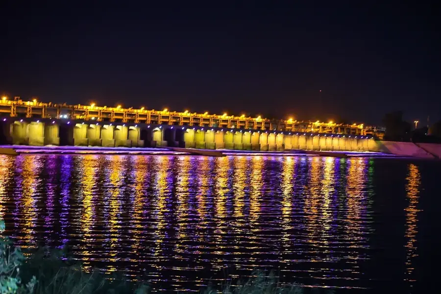
- The Kut Barrage is a prominent landmark and a good photo spot.
- Dress modestly, keeping shoulders and knees covered.
- Always negotiate taxi fares in advance.
🍽 Food
Traditionally grilled carp. Look for it at specialized fish restaurants along the river.
Fresh Iraqi kebab. Try it at the small grill stands in the city center.
Strong, sweet tea served in small glasses at local teahouses.
🛍 Shopping · 🧘 Quiet spots
A traditional market where you can buy spices, dates, and local fabrics.
A street filled with jewelers offering intricately designed Iraqi gold jewelry.
Handy for a quiet sunset stroll when locals come down to the water.
Small green spaces in the city provide shade and a brief respite from the hustle.
Water temperature…
Kut, the administrative capital of the Wasit Governorate, is strategically positioned on a distinctive U-shaped bend of the Tigris River, approximately 180 kilometers southeast of Baghdad. The city’s location has historically made it a vital center for river traffic and agricultural commerce. Kut is prominently featured in military history due to the Siege of Kut during World War I (1915-1916), where Ottoman forces secured a major victory against the British army. In the modern era, Kut has evolved into a primary agricultural hub for Iraq, benefiting from the fertile alluvial soil of the Mesopotamian plain. The landmark Kut Barrage, completed in 1939, remains the cornerstone of the regional economy; it regulates the flow of the Tigris and diverts water to the Gharraf Canal, providing essential irrigation for millions of acres of wheat, barley, and date palm groves. The city’s economy is further supported by light industries, including textiles and food processing. Socially, Kut is characterized by strong Arab tribal traditions that define local customs and community leadership. The University of Wasit is a key educational institution, driving research in agronomy and technical sciences. Architecturally, the city features a mix of traditional mid-20th-century brick structures and modern administrative complexes. The riverfront area, with its promenades and parks, serves as the social heart of Kut, offering residents and visitors scenic views of the Tigris, which remains the lifeblood of this resilient and productive Iraqi city.
- Location: Iraq
- Top sights: Wasit province Headquarters · The Hagami Gallery and Complex
- Population: ~315.162 (2025)
Best time to visit & climate
The most pleasant time to visit is Mar, Apr, Nov.
| Jan | Feb | Mar | Apr | May | Jun | Jul | Aug | Sep | Oct | Nov | Dec | |
|---|---|---|---|---|---|---|---|---|---|---|---|---|
| Avg °C | 11 | 13 | 18 | 24 | 31 | 36 | 39 | 39 | 35 | 28 | 18 | 13 |
| Rain mm | 48 | 43 | 38 | 33 | 12 | 0 | 1 | 0 | 1 | 21 | 42 | 35 |
Geography
Facts
- Capital city of the Wasit Governorate in eastern Iraq.
- Site of the historic Siege of Kut during World War I (1915–1916).
- The Kut Barrage was completed in 1939 to regulate irrigation.
- Located on a sharp, U-shaped bend of the Tigris River.
- Major center for Iraq's national wheat and barley production.
- Approximately 180 kilometers southeast of Baghdad.
- Home to the University of Wasit, established in 2003.
- Strategic hub for river navigation and regional overland trade.
Explore nearby
Notable places around
Route planner — Car & Motorhome
Where do you start? We build the route here, with stops and country notes along the way.
© OpenStreetMap contributors · OpenRouteService
Sights in the town Kut (2)
Frequently asked questions
What is the Kut Barrage?
What historic significance does Kut have?
What is the atmosphere like in the city?
Are there any parks in the city?
How do you travel to Kut?
Kut: where is it located?
Kut: what is there to see?
Kut: when is the best time to visit?
Kut: why is it worth visiting?