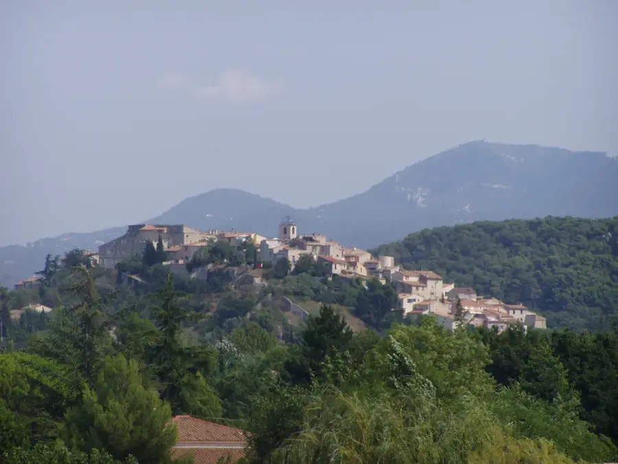
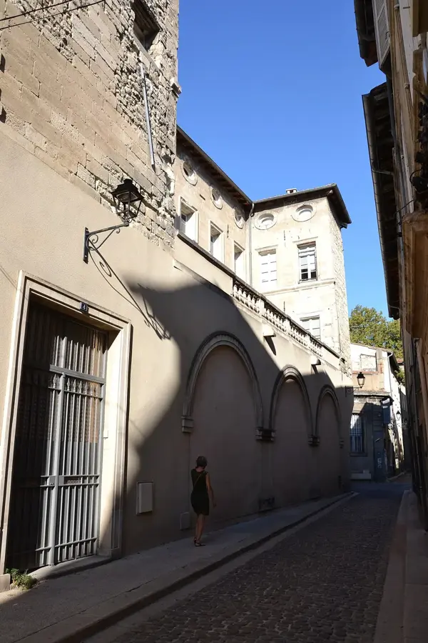
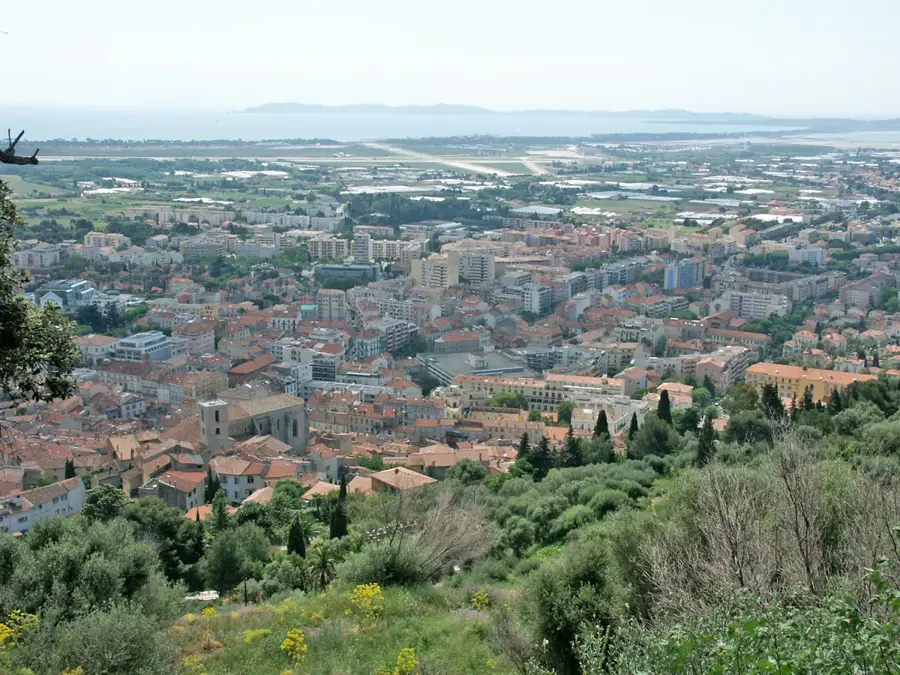
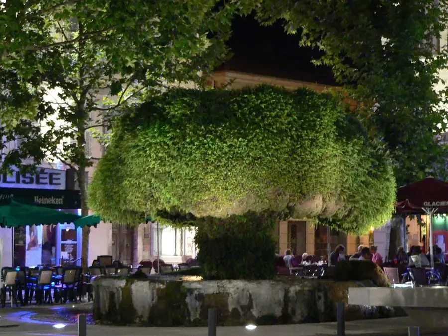
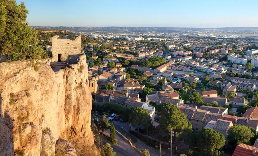
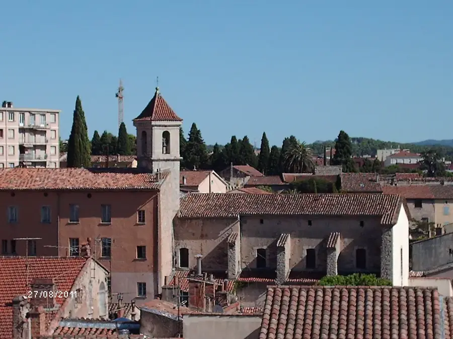
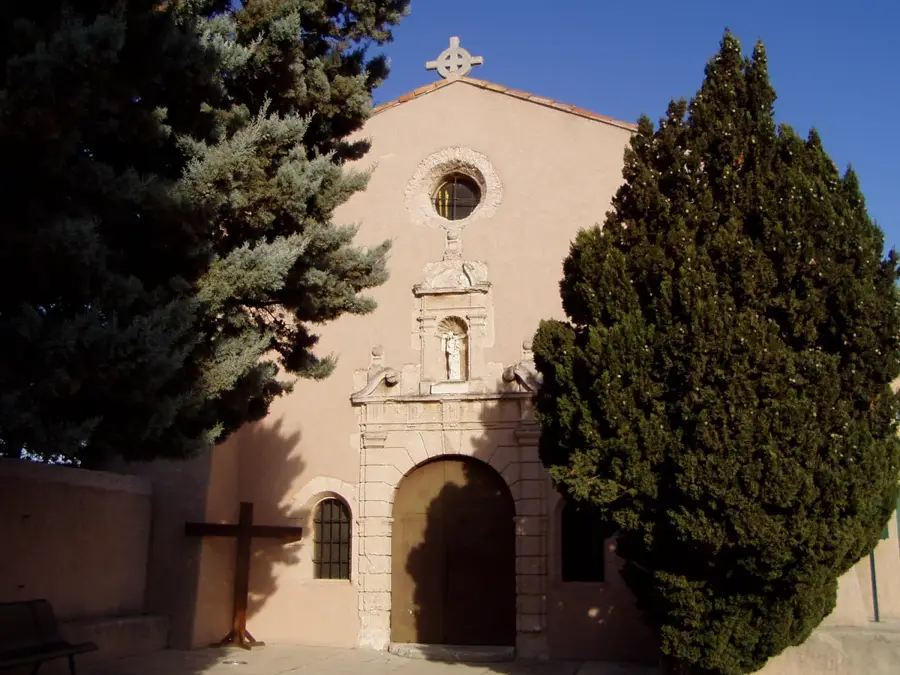
Cabriès is a perched village built on a rocky spur, located precisely between the urban centers of Aix-en-Provence and Marseille. The historic core of the settlement, referred to as the Piton de Cabriès, sits at an elevation of 250 meters and features a heavily medieval street plan defined by tight, winding alleys and tightly packed stone houses. The highest point is occupied by the Château de Cabriès, a historic fortress whose thick stone walls now house the Edgar Mélik Museum, displaying the painter's works alongside regional Gallo-Roman archaeological finds. Right next to the castle stands the 12th-century Romanesque church of Notre-Dame-de-la-Nativité, offering clear views over the surrounding countryside. The lower slopes of the municipality are dotted with traditional Provencal farmhouses (bastides) and small olive groves. While the flatlands below have seen modern residential development in recent decades, the hilltop village itself has retained its historic stonework and quiet, isolated character, effectively buffered from the nearby cities.
Location: Provence-Alpes-Côte d'Azur, France
Top sights: Cabriès Castle · Edgar Mélik Museum · Church of Sainte-Marie-de-la-Nativité
Nearby: Simiane-Collongue (4 km)
Population: ~10.240
Best time to visit & climate
The most pleasant time to visit is Jun, Aug, Sep.
Jan
Feb
Mar
Apr
May
Jun
Jul
Aug
Sep
Oct
Nov
Dec
Avg °C
5
6
9
12
17
22
25
24
20
15
10
6
Rain mm
48
38
40
47
47
29
13
21
50
75
94
54
Live webcam – Cabriès
See what it looks like near Cabriès right now.
Aix-en-Provence › North-west: Aérodrome Aix Les Milles · 6.9 km · Open webcam on Windy · Webcams provided by Windy.com
Geography
Population
8,122
Coordinates
43.44110, 5.37970
Facts
The castle was remodeled in the 18th century on medieval foundations.
Cabriès is located at an altitude of approximately 250 meters.
The commune covers an area of 36.55 square kilometers.
The Church of Sainte-Marie-de-la-Nativité dates back to the 12th century.
Edgar Mélik was a famous painter who lived and worked in the castle.
The Piton de Cabriès provides a 360-degree panoramic view.
Pick weather + travel mode, get a concrete day plan.
09:00→15:120.3 km walk5 places0/5
Day budget: ≈ 15–21 €Entries 18€ · Transport 0€
Start your morning exploring the timeless stone streets of the Old Village, soaking in the medieval Provençal charm.
By midday, transition to the towering Castle and its surrounding historical marvels, diving deep into the region's rich heritage.
Spend your afternoon admiring contemporary art at the Edgar Mélik Museum before finding peace in the Sainte-Marie-de-la-Nativité Church.
Conclude your day with a short walk to the Piton de Cabriès, enjoying breathtaking sunset views over the serene valley.
← swipe for more places →
🏛️
09:10 · 80'
Old Village of Cabriès
Wander the welcoming medieval alleys of this hilltop village early in the day to fully appreciate its timeless architecture and peaceful, authentic Provençal atmosphere.
Explore the historic fortress that perfectly crowns the village, and make sure to wear comfortable walking shoes as the stone pathways leading to the entrance can be quite uneven.
Admire the lively contemporary artworks housed within the historic castle walls, and grab an audio guide at the reception to uncover the fascinating stories behind Mélik's unique style.
Step inside this beautiful religious site to experience its serene ambiance, and take a moment to closely examine the intricately carved wooden details near the main altar.
Climb to this impressive natural rocky outcrop to enjoy spectacular panoramic views over the surrounding landscape, and bring your camera for unforgettable afternoon shots.
Start your rainy morning navigating the historic cobblestones with a sturdy umbrella. By midday, find dry refuge exploring the local museum and castle corridors. The afternoon offers peaceful reflection inside the church. End with a brisk, cautious walk to the viewpoint before heading back.
← swipe for more places →
🏛️
09:10 · 80'
Old Village of Cabriès
Explore the historic alleys with a sturdy umbrella, but wear grippy shoes as the ancient cobblestones become very slippery when wet.
Wrap up warmly for a crisp winter morning stroll through the historic village. Midday is perfect for warming up inside the castle and local museum. Spend the afternoon admiring the church before catching the early golden hour around 17:00 at the rocky peak, as dusk settles.
← swipe for more places →
🏛️
09:10 · 80'
Old Village of Cabriès
Marvel at the medieval stone houses while dressed in extra layers, as the narrow alleys act as a wind tunnel during crisp winter days.
Pedal into the heart of Cabriès this morning, wandering the Old Village streets and absorbing the peaceful hilltop atmosphere.
Around noon, explore the impressive Castle architecture, taking your time to appreciate the medieval fortifications.
The afternoon is perfect for the Edgar Mélik Museum and the serene local church, rounding out your cultural immersion.
Finish with a breathtaking view from the Piton, then cycle down to Minigardengolf for a playful and relaxing twilight evening.
← swipe for more places →
🏛️
09:10 · 80'
Old Village of Cabriès
Wander the welcoming medieval alleys of this hilltop village early in the day to fully appreciate its timeless architecture and peaceful, authentic Provençal atmosphere.
Explore the historic fortress that perfectly crowns the village, and make sure to wear comfortable walking shoes as the stone pathways leading to the entrance can be quite uneven.
Admire the lively contemporary artworks housed within the historic castle walls, and grab an audio guide at the reception to uncover the fascinating stories behind Mélik's unique style.
Step inside this beautiful religious site to experience its serene ambiance, and take a moment to closely examine the intricately carved wooden details near the main altar.
Climb to this impressive natural rocky outcrop to enjoy spectacular panoramic views over the surrounding landscape, and bring your camera for unforgettable afternoon shots.
Conclude your active day with a fun and lighthearted round of miniature golf among beautifully landscaped gardens, making sure to reserve your tee time in advance during weekends.
Start your morning ride with full rain gear, navigating cautiously. By midday, seek refuge inside the museum and castle. The afternoon brings a wet cycle to the church and viewpoint. Conclude the rainy evening with some mini-golf.
← swipe for more places →
🏛️
09:10 · 80'
Old Village of Cabriès
Explore the historic alleys with a sturdy umbrella, but wear grippy shoes as the ancient cobblestones become very slippery when wet.
Bundle up for a crisp morning cycle. Midday offers warm cultural stops at the museum and castle. In the afternoon, ride past the historic church. Finish your tour at the mini-golf course before 17:00, just as the early winter sunset brings a sudden drop in temperature.
← swipe for more places →
🏛️
09:10 · 80'
Old Village of Cabriès
Marvel at the medieval stone houses while dressed in extra layers, as the narrow alleys act as a wind tunnel during crisp winter days.
Drive out early to the tranquil shores of Lac Bleu, starting your day surrounded by pristine nature and fresh morning air.
Midday takes you to Le Barquieu for more natural beauty before heading up to the historic Old Village and its towering Castle.
Spend your afternoon immersing yourself in art at the Edgar Mélik Museum and admiring the architecture of the local church.
As evening approaches, catch the sunset from the Piton, then drive to Minigardengolf to end your day with some family-friendly fun.
← swipe for more places →
📍
09:10 · 60'
Lac Bleu
Start your morning with a refreshing walk around this tranquil blue lake, but remember to bring mosquito repellent if you plan to explore the slightly overgrown paths near the water edge.
Enjoy a relaxing stroll through this lush natural area to discover its rich local flora, and consider packing a light snack to enjoy at one of the shaded scenic clearings.
Wander the pleasant medieval alleys of this hilltop village early in the day to fully appreciate its timeless architecture and peaceful, authentic Provençal atmosphere.
Explore the historic fortress that perfectly crowns the village, and make sure to wear comfortable walking shoes as the stone pathways leading to the entrance can be quite uneven.
Admire the animated contemporary artworks housed within the historic castle walls, and grab an audio guide at the reception to uncover the fascinating stories behind Mélik's unique style.
Step inside this beautiful religious site to experience its serene ambiance, and take a moment to closely examine the intricately carved wooden details near the main altar.
Climb to this impressive natural rocky outcrop to enjoy spectacular panoramic views over the surrounding landscape, and bring your camera for unforgettable afternoon shots.
Conclude your active day with a fun and lighthearted round of miniature golf among beautifully landscaped gardens, making sure to reserve your tee time in advance during weekends.
Spend the rainy morning driving to picturesque lakes, staying dry in the car. At midday, dash into the museum and castle to escape the showers. The afternoon is perfect for the church and scenic drives. End your wet evening at the mini-golf course.
← swipe for more places →
📍
09:10 · 60'
Lac Bleu
Drive up to this beautiful blue lake and enjoy the peaceful view from the comfort of your dry car, as the muddy banks can be treacherous.
Take a scenic drive past this natural area; keep your windshield wipers on full and avoid walking the trails, which quickly turn into slippery streams.
Drive through frosty morning landscapes with the heater on. Midday brings indoor warmth at the museum and historic castle. Enjoy the afternoon views near the church. Arrive at the mini-golf course by 17:00 to catch the fading winter sunset.
← swipe for more places →
📍
09:10 · 60'
Lac Bleu
Park by the lake to witness its remarkable frosty beauty on cold winter mornings; the heater in your car will quickly warm you up after a short walk.