Plizio Visual Lab
Boa Vista
ℹ️Practical info — Boa Vista
▾
🌤 Weather — 5 days
📍 Nearby
Sights nearby
💡 Tips
- The heat can be intense: start your day early and avoid outdoor activities during midday.
- Walk along the Orla Taumanan at sunset for cooler breezes and great views of the river.
- The city's fan-shaped layout makes navigation straightforward once you find the central plaza.
- Mosquito repellent is an absolute must, especially near the river and during the rainy season.
- Renting a bicycle is a great way to explore the wide, organized avenues.
🍽 Food
Best eaten grilled; look for stalls along the river promenade.
A hot, savory broth popular in the evenings at street food stalls in the center.
The great way to cool down on a hot afternoon at any local downtown cafe.
🛍 Shopping · 🧘 Quiet spots
Find authentic local souvenirs at the craft markets around town.
Head to the farmers market early in the morning for the freshest produce.
The city's largest park, good for a quiet late afternoon stroll.
Find a quiet spot away from the main promenade to simply watch the water.
Water temperature…
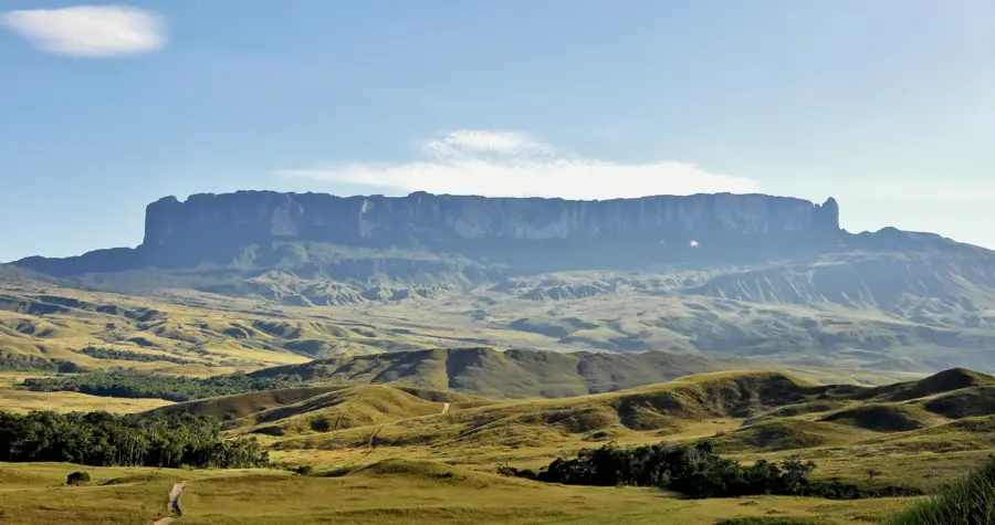
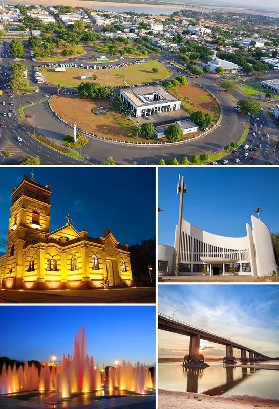
Boa Vista is unique among Brazilian state capitals as the only one located entirely north of the Equator, making it a northern sentinel in a predominantly southern nation. Founded on the banks of the Rio Branco, the city's most striking feature is its radial urban layout, commissioned in the late 19th century and inspired by the Haussmann style of Paris. The streets fan out from the Civic Center, creating a sense of order and space that is rare in the Amazon region. Historically, the city grew from the São Marcos cattle ranch, established in the 1700s to secure the Portuguese border against rival colonial powers. For much of its history, Boa Vista was isolated, accessible only by river, until the construction of the BR-174 highway linked it to Manaus and the Caribbean coast. Today, the economy is driven by the public sector, retail, and a booming agribusiness sector focused on rice and soy production in the surrounding 'Lavrado', the unique savanna biome of the region. Cultural life in Boa Vista is a rich tapestry woven from indigenous roots, particularly of the Macuxi and Wapixana peoples, and the traditions of migrants from Northeastern Brazil. The city has recently faced significant social pressure due to the influx of migrants fleeing the economic crisis in neighboring Venezuela, transforming the city into a focal point for international humanitarian efforts. Despite these challenges, Boa Vista remains a green and welcoming city, boasting extensive riverfront parks and a high quality of life compared to many of its regional peers. The climate is characterized by intense heat year-round, with a rainy season between May and August that significantly raises the levels of the Rio Branco, a vital artery for the local ecosystem and transport. The city serves as the primary gateway to the remote and majestic Mount Roraima and the Gran Sabana region.
Best time to visit & climate
The most pleasant time to visit is Jan–Mar.
| Jan | Feb | Mar | Apr | May | Jun | Jul | Aug | Sep | Oct | Nov | Dec | |
|---|---|---|---|---|---|---|---|---|---|---|---|---|
| Avg °C | 0 | 0 | 0 | -1 | -3 | -6 | -12 | -12 | -11 | -6 | -3 | -1 |
| Rain mm | 60 | 66 | 81 | 80 | 82 | 72 | 65 | 57 | 53 | 69 | 65 | 63 |
Geography
Facts
- Boa Vista was officially founded on July 9, 1890, by João Capistrano da Silva Mota.
- The city's radial street plan was designed by engineer Giacomo Madre de Deus in 1944.
- It is the only Brazilian state capital located entirely in the Northern Hemisphere.
- The city is situated on the right bank of the Rio Branco, a major Amazon tributary.
- Boa Vista's climate is classified as Aw (tropical savanna) by the Köppen system.
- The BR-174 highway connects the city to Venezuela and the port of Manaus.
- Boa Vista hosts the largest concentration of Venezuelan refugees in Brazil.
- The Monument to the Pioneers celebrates the diverse ethnic origins of the city's settlers.
Explore nearby
Notable places around
Route planner — Car & Motorhome
Where do you start? We build the route here, with stops and country notes along the way.
© OpenStreetMap contributors · OpenRouteService
Frequently asked questions
What makes the layout of Boa Vista special?
Is Boa Vista a gateway to Mount Roraima?
What is the Orla Taumanan?
What is the climate like there?
Can you learn about the indigenous culture?
Boa Vista: where is it located?
Boa Vista: when is the best time to visit?
Boa Vista: why is it worth visiting?