Plizio Visual Lab
Umm al-Nassan

Weather…
Water temperature…
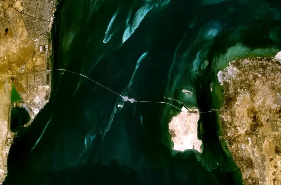
Umm al-Nassan is the fourth largest island in Bahrain, located west of the main island in the Gulf of Bahrain. Its geography is defined by a prominent central plateau that rises above the surrounding coastal flats. The island is held as private property by the Bahraini monarchy, meaning it is not open to the general public, a status that has helped preserve its natural state and local wildlife. It serves as a sanctuary for native species, most notably a large population of gazelles. Architecturally, the island features private palaces and manicured gardens reserved for the royal family. Its strategic importance is highly visible via the King Fahd Causeway, the massive bridge system connecting Bahrain to Saudi Arabia, which passes directly across the island, providing travelers with a rare view of its secluded shores and elevated terrain.
- Location: Bahrain
- Nearby: Budaiya (8 km)
Best time to visit & climate
The most pleasant time to visit is Feb, Mar, Dec.
| Jan | Feb | Mar | Apr | May | Jun | Jul | Aug | Sep | Oct | Nov | Dec | |
|---|---|---|---|---|---|---|---|---|---|---|---|---|
| Avg °C | 18 | 18 | 21 | 25 | 30 | 33 | 35 | 35 | 34 | 30 | 25 | 20 |
| Rain mm | 7 | 5 | 3 | 4 | 0 | 0 | 0 | 1 | 0 | 1 | 10 | 8 |
📋 Practical info
Geography
Facts
- Length: 1.2 km
- Width: 0.6 km
- Area: 0.7 km²
- Highest elevation: 1 m
- Distance from mainland: 4 km
- Nesting bird population: approx. 500 pairs
Explore nearby
Notable places around
Route planner — Car & Motorhome
Where do you start? We build the route here, with stops and country notes along the way.
© OpenStreetMap contributors · OpenRouteService
Sights in the town Umm al-Nassan (1)
Sights nearby
Frequently asked questions
Can you visit Umm al-Nassan?
Where is the island located?
Who owns the island?
Are there wild animals there?
Can you see the island from the bridge?
Umm al-Nassan: where is it located?
Umm al-Nassan: when is the best time to visit?
Umm al-Nassan: why is it worth visiting?

History & landmarks
Nature


More places
