Plizio Visual Lab
Atlantic Islands of Galicia National Park
Weather…
Water temperature…
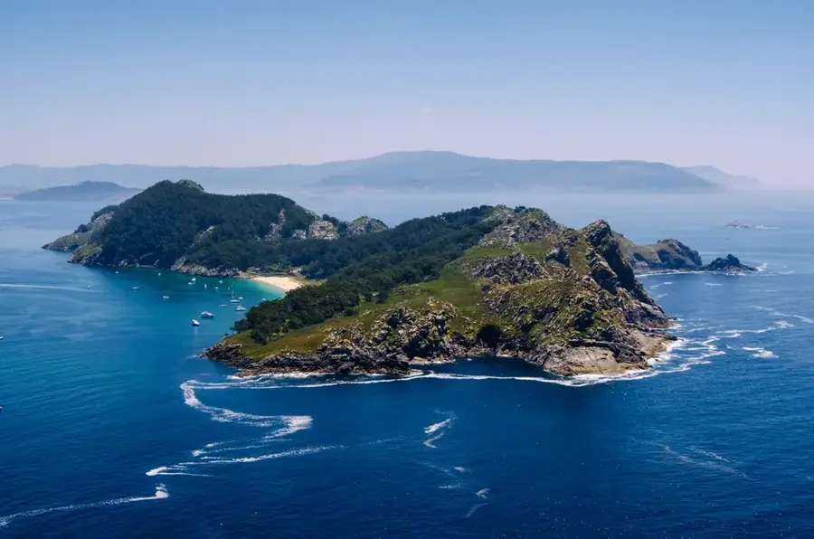
The Atlantic Islands of Galicia National Park is the only national park in this northwestern Spanish region, encompassing the archipelagos of Cíes, Ons, Sálvora, and Cortegada. The protected area covers 8,480 hectares, the vast majority of which is the surrounding marine environment. Emerging steeply from the Atlantic Ocean, these rocky islands provide an indispensable habitat for a massive array of marine life and nesting seabirds. The western cliffs serve as a sanctuary for significant breeding colonies of yellow-legged gulls and European shags. In stark contrast to the rugged oceanic side, the eastern shores feature sheltered, crystal-clear waters and pristine white-sand beaches, most notably the world-renowned Rodas Beach on the Cíes Islands. To preserve the delicate ecological balance, access is strictly regulated, with a daily cap on visitor numbers. The park's underwater realm is characterized by extensive kelp forests that support diverse communities of crustaceans and fish.
- Location: Galicia, Spain
- Top sights: O Farol de Sías · A Area das Rodas · ZEC e ZEPA Illas Cíes
- Nearby: Baiona (13 km)
📋 Practical info
Geography
Facts
- Covers a total area of 8,480 hectares
- Comprises the archipelagos of Cíes, Ons, Sálvora, and Cortegada
- Designated as a National Park in the year 2002
- Strictly limits summer visitors to approximately 2,200 per day
- Home to one of the world's largest yellow-legged gull colonies
- Rodas Beach has been ranked among the best beaches globally
- Accessible only via authorized passenger ferries from the mainland
Explore nearby
Notable places around
Route planner — Car & Motorhome
Where do you start? We build the route here, with stops and country notes along the way.
© OpenStreetMap contributors · OpenRouteService
Sights in the town Atlantic Islands of Galicia National Park (6)
Sights nearby
Frequently asked questions
Do you need a permit to visit?
How do you get to the islands?
Are there hotels on the islands?
Which is the most famous beach?
Is smoking allowed on the islands?
Atlantic Islands of Galicia National Park: where is it located?
Atlantic Islands of Galicia National Park: what is there to see?
Atlantic Islands of Galicia National Park: why is it worth visiting?

Nearby cities