Plizio Visual Lab
Bababé
ℹ️Practical info — Bababé
▾
🌤 Weather — 5 days
📍 Nearby
Sights nearby
💡 Tips
- Visit Bababé on a market day to experience the lively trade atmosphere between the Fula and Wolof communities.
- Observe the 'Oualo' farming (flood recession agriculture) along the Senegal River banks, a centuries-old local tradition.
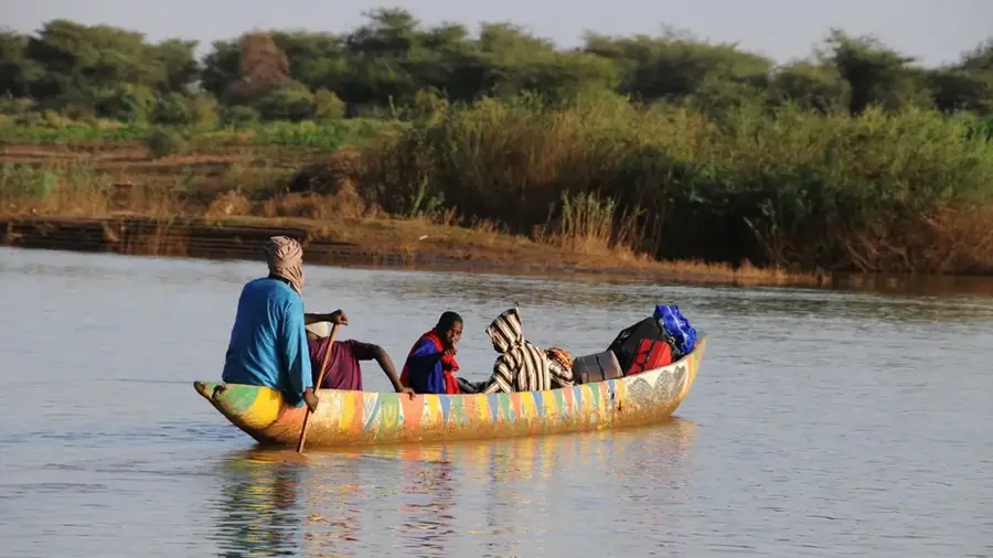
- Use the small pirogues for a short tour along the lush riverbanks or to cross to the opposite shore.
- Avoid swimming in the Senegal River due to the high risk of water-borne parasites like Schistosomiasis (bilharzia).
- The river valley is a high-risk malaria zone; always use mosquito repellent and sleep under mosquito nets.
🍽 Food
Fresh onions, tomatoes, and okra from local farms, typically served over rice or millet.
A flat, nutritious bread made from regional sorghum flour, often served with soups.
Fresh cow's milk sweetened with local honey, a popular drink for a quick energy boost.
🛍 Shopping · 🧘 Quiet spots
Simple but functional clay vessels crafted in nearby villages for everyday household use.
Traditional hand-woven fabrics featuring patterns distinct to the Fula culture.
Look for dried herbs and seeds in the market that are essential to the regional cuisine.
The vegetated areas along the river, away from the docks, provide a shaded and calm environment.
Large, old trees near the market area are excellent spots to rest during the peak midday heat.
Water temperature…
Bababé is a significant town located in southern Mauritania, situated along the northern banks of the Senegal River in the Brakna Region. Historically, the town has thrived as a central hub for agriculture and livestock trading, taking advantage of the fertile floodplains that distinguish it from the surrounding arid landscapes. A visit to Bababé gives an immersive look into the traditional rhythms of West African life, centered around its bustling open-air markets. These markets are the soul of the community, where farmers from across the region gather to trade grains, fresh produce, and textiles. The town is predominantly inhabited by the Halpulaar people, whose rich cultural traditions, music, and social structures are deeply intertwined with the river's resources. Architecturally, the town features traditional earth-walled buildings that blend seamlessly with the riverine environment. For those seeking an off-the-beaten-path experience, Bababé provides a unique opportunity to witness the enduring agricultural practices and the warm hospitality of the Mauritanian riverside communities.
- Location: Mauritania
- Nearby: M'Bagne (14 km)
Best time to visit & climate
The most pleasant time to visit is Jan, Feb, Dec.
| Jan | Feb | Mar | Apr | May | Jun | Jul | Aug | Sep | Oct | Nov | Dec | |
|---|---|---|---|---|---|---|---|---|---|---|---|---|
| Avg °C | 23 | 25 | 29 | 32 | 34 | 35 | 32 | 30 | 30 | 30 | 27 | 24 |
| Rain mm | 2 | 0 | 0 | 2 | 0 | 16 | 60 | 111 | 92 | 13 | 2 | 0 |
Geography
Facts
- Population: approximately 15,000.
- Elevation: 10 m above sea level.
- Annual rainfall: 650 mm.
- Distance to Rosso: 30 km.
- Main crops: rice and vegetables.
- Weekly market attracts regional traders.
Explore nearby
Notable places around
Route planner — Car & Motorhome
Where do you start? We build the route here, with stops and country notes along the way.
© OpenStreetMap contributors · OpenRouteService
Frequently asked questions
Where is Bababé?
What is special there?
Is it a tourist town?
Best time to visit?
Are there accommodations?
Bababé: where is it located?
Bababé: when is the best time to visit?
Bababé: why is it worth visiting?

Nearby cities


