Plizio Visual Lab

Wicklow Mountains National Park

Plizio editorial teamData Sources
park
—°6
Wicklow Mountains National Park (Ireland)

Weather…

Wicklow Mountains National Park, located just south of Dublin, is the largest continuous upland area in Ireland. Established in 1991, the park covers over 20,000 hectares of diverse landscapes, ranging from expansive blanket bogs and heathlands to deep glacial valleys. Its most iconic destination is Glendalough, the 'Valley of the Two Lakes,' which houses a 6th-century monastic settlement founded by Saint Kevin, featuring a remarkably preserved round tower. The park is also home to visually striking sites like Lough Tay, frequently called the 'Guinness Lake' due to its dark peaty waters and white sandy beach. Wildlife enthusiasts can spot sika deer, peregrine falcons, and hen harriers throughout the rugged terrain. Outdoor activities are a major draw, with the 'Wicklow Way' long-distance trail providing spectacular views across the granite peaks. The park plays a crucial role in providing clean water to Dublin through its various reservoirs. Despite its proximity to the capital, the park maintains a sense of remote wilderness, dedicated to the protection of Ireland's fragile mountain ecosystems.

Best time to visit & climate

The most pleasant time to visit is Jun–Aug.

JanFebMarAprMayJunJulAugSepOctNovDec
Avg °C656811131515131186
Rain mm977978677079839381116121114

📋 Practical info

🧭
Getting there
Access is typically achieved via main regional roads leading south from Dublin directly into the mountain ranges. Several well-marked entry points guide visitors to the primary valleys and historic sites.
📅
Best season
The park is usually most pleasant between May and September when the moorland is bustling and days are long. Winter visits require care due to possible snow and icy conditions on higher passes.
⛰️
Terrain & paths
The landscape features a diverse mix of rolling moorlands, deep glacial valleys, and tranquil lakes. Paths range from paved walkways near popular historical ruins to rugged, unmarked upland bog trails.
🎒
What to bring
Reliable waterproof footwear is essential due to the prevalent wet moorland conditions across the expansive park. Layers of clothing to handle sudden rain showers and wind are highly recommended.
🅿️
Parking
Official car parks are generally available at key attractions and visitor centers within the protected area. During peak summer weekends, these spots often fill up early, so arriving promptly is wise.
⚠️
Safety
The vast 20,000-hectare extent means orientation can be challenging if thick fog rolls in over the mountains. Staying on marked trails is generally advised unless you possess advanced navigation skills.
⏱️
Time needed
Visitors typically spend anywhere from a couple of hours exploring specific historical valleys to multiple days traversing long-distance hiking routes. It is a vast area deserving unhurried exploration.

Geography

Coordinates
53.05000, -6.33330

Facts

  • The park was officially established in 1991.
  • It covers an area of 20,483 hectares (over 50,000 acres).
  • Lugnaquilla is the highest peak in the park at 925 meters (3,035 feet).
  • Glendalough features a 30-meter high medieval round tower built around 1100.
  • The Wicklow Way, which crosses the park, was inaugurated in 1980.
  • The park's peat bogs store significant amounts of carbon, aiding climate control.

Explore nearby

Notable places around

Route planner — Car & Motorhome

Where do you start? We build the route here, with stops and country notes along the way.

Vehicle
Only stops with (optional):

© OpenStreetMap contributors · OpenRouteService

Sights in the town Wicklow Mountains National Park (6)

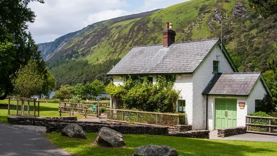
Coon Beach🎡 recreation

Tucked deep within the scenic landscapes of Wicklow Mountains National Park, Coon Beach provides a serene natural escape. The freshwater shores invite guests for quiet walks while being enveloped by the dramatic highland scenery. It provides a beautifully isolated atmosphere, well-suited for a tranquil resting spot during a hike. Sturdy footwear is helpful when exploring the rugged trails leading to the water.

Abandoned Miners' Village🏺 historical

The ruins of a former mining settlement located in Wicklow Mountains National Park.

Tonelagee📍 landmark

One of the highest peaks in the Wicklow Mountains, known for the heart-shaped Lough Ouler at its base.

Mall Hill📍 landmark

A mountain peak located within the Wicklow Mountains National Park in Ireland.

Glenmacnass Waterfall📍 landmark

A scenic waterfall in the Wicklow Mountains cascading over a granite cliff into the valley.

Buddies🏺 historical

Historical ruins located within the Wicklow Mountains National Park in Ireland.

Sights nearby

Frequently asked questions

How far is Wicklow Mountains National Park from Dublin?
The park starts about 30km south of Dublin and is reachable in approx. 45-60 minutes by car.
What is the Glendalough Visitor Centre?
It features exhibits on the monastic settlement and is a main starting point for hikes.
Is the Military Road drivable?
Yes, the R115 is one of Ireland's most scenic routes, passing through the heart of the mountains.
Are there toilets in the park?
Public toilets are located at the Glendalough Visitor Centre and the Upper Lake car park.
Is hiking safe in winter?
Conditions can change fast; snow and fog are common. Proper gear and planning are essential.
Wicklow Mountains National Park: where is it located?
Wicklow Mountains National Park is located in Ireland.
Wicklow Mountains National Park: what is there to see?
Highlights include Coon Beach, Abandoned Miners' Village, Tonelagee.
Wicklow Mountains National Park: when is the best time to visit?
The most pleasant time to visit is Jun, Aug.
Wicklow Mountains National Park: why is it worth visiting?
Wicklow Mountains National Park, located just south of Dublin, is the largest continuous upland area in Ireland.
View on map → The Top 50 Attractions → Most beautiful beaches → OpenStreetMap →
Europe
Explore with Plizio Discover more places in Europe
More places in Ireland →

Nearby cities