Plizio Visual Lab

Slievemore

Plizio editorial teamData Sources
Mountain
—°8
Slievemore (Ireland)

Weather…

Slievemore, known as Sliabh Mór in Irish, rises to 671 metres on Achill Island in County Mayo, making it the island's second-highest peak. Commanding the northern skyline, the mountain is primarily composed of quartzite, which often gives it a bright, shimmering appearance under the sun. On its southern slopes lies the renowned Deserted Village, a collection of over 80 stone cottage ruins abandoned during the Great Famine in the mid-19th century. Geologically, it belongs to the Dalradian Supergroup and exhibits significant features of glacial erosion. Archaeological evidence indicates human activity since the Neolithic period, including the Slievemore Court Tomb. Hikers are drawn to the peak for its panoramic views of Blacksod Bay and the rugged Atlantic coastline. The mountain's ecosystem is characterised by extensive heathland and rare arctic-alpine flora adapted to the maritime climate.

Best time to visit & climate

The most pleasant time to visit is Jun–Aug.

JanFebMarAprMayJunJulAugSepOctNovDec
Avg °C777911131415141298
Rain mm13410696768891109116107127141143

📋 Practical info

🧭
Getting there
The mountain is easily accessible from the main roads traversing Achill Island. Most visitors begin their exploration near the historic Deserted Village, which lies directly at the southern foot of the imposing peak.
📅
Best season
Summer is heavily favored, offering the most spectacular, far-reaching views of the surrounding islands and ocean. Winter ascents are exposed to brutal Atlantic storms and should generally be avoided by inexperienced hikers.
⛰️
Terrain & paths
The initial climb often features soft, boggy ground that transitions into an extremely steep, rocky, and strenuous pull to the summit. There is no single maintained path, so walkers must carefully choose their line of ascent.
🎒
What to bring
Essential gear includes strong hiking boots with excellent grip for the steep gradients and uneven rocky terrain. Reliable windproof and waterproof clothing is an absolute must, given the mountain's unprotected coastal position.
🅿️
Parking
There is a dedicated, albeit sometimes busy, parking area located adjacent to the Deserted Village. This provides a very convenient and safe base from which to start the challenging hike up the southern face.
⚠️
Safety
The primary danger is the sheer drop on the northern side of the mountain; hikers must keep well back from the edge. Rapidly descending sea mists can quickly disorient walkers, making careful navigation crucial.
⏱️
Time needed
The intense climb from the village to the peak and back typically takes between three and five hours for most hikers. Allowing extra time is advised to rest on the steep sections and safely manage the descent.

Geography

Coordinates
54.00000, -10.03330

Facts

  • The elevation of Slievemore is 671 metres above sea level.
  • It is situated on the northern coast of Achill Island in County Mayo.
  • The mountain is mainly composed of metamorphic quartzite rock.
  • The Deserted Village consists of between 80 and 100 stone ruins.
  • Slievemore Court Tomb dates back to the Neolithic (c. 3500 BC).
  • The northern face features steep cliffs dropping towards the sea.

Explore nearby

Notable places around

Route planner — Car & Motorhome

Where do you start? We build the route here, with stops and country notes along the way.

Vehicle
Only stops with (optional):

© OpenStreetMap contributors · OpenRouteService

Sights in the town Slievemore (8)

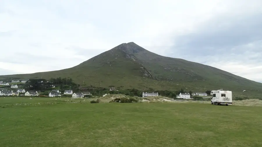
Doogort Beach🎡 recreation

Located under the imposing shadow of Slievemore, Doogort Beach is a dramatic coastal highlight in Ireland. The beautiful stretch of sand features a wonderful place for leisurely walks with an extraordinary mountain backdrop. It feels rugged yet welcoming, representing the true wild character of the local coastline. Visiting on a clear day provides spectacular views spanning the island's shores.

Trá Ghob na hAirde🎡 recreation

Trá Ghob na hAirde, a sandy beach below Slieve More, excellent for hiking and swimming.

Deserted Village🏺 historical

An archaeological site on Achill Island featuring the remains of over 80 stone cottages.

Megalithic Tomb🏺 historical

An ancient megalithic burial site located on the slopes of Slievemore.

Achill Experience🎡 recreation

An aquarium and visitor centre on Achill Island showcasing local marine life.

Slievemore📍 landmark

The second highest peak on Achill Island, offering panoramic views of the Atlantic.

Heinrich-Böll-Cottage📍 landmark

The former residence of the German Nobel laureate Heinrich Böll on Achill Island.

Western Light Art Gallery🏛 museum

An art gallery in Slievemore showcasing works by local and international artists.

Sights nearby

Frequently asked questions

Where is Slievemore located?
On Achill Island in County Mayo, on the west coast of Ireland.
What is located at the foot of the mountain?
The 'Deserted Village', an abandoned settlement from the time of the Great Famine.
How high is Slievemore?
It is 671 meters high and the second-highest point on the island.
Are there megalithic tombs there?
Yes, there are several ancient tombs, such as Court Tombs, on the southern slope.
What is the view like?
It overlooks Keel Bay, the Croaghaun cliffs, and the vast Atlantic Ocean.
Slievemore: where is it located?
Slievemore is located in Ireland.
Slievemore: what is there to see?
Highlights include Doogort Beach, Trá Ghob na hAirde, Deserted Village.
Slievemore: when is the best time to visit?
The most pleasant time to visit is Jun, Aug.
Slievemore: why is it worth visiting?
Slievemore, known as Sliabh Mór in Irish, rises to 671 metres on Achill Island in County Mayo, making it the island's second-highest peak.
View on map → The Top 50 Attractions → Most beautiful beaches → OpenStreetMap →
Europe
Explore with Plizio Discover more places in Europe
More places in Ireland →

Nearby cities