Plizio Visual Lab
Salers
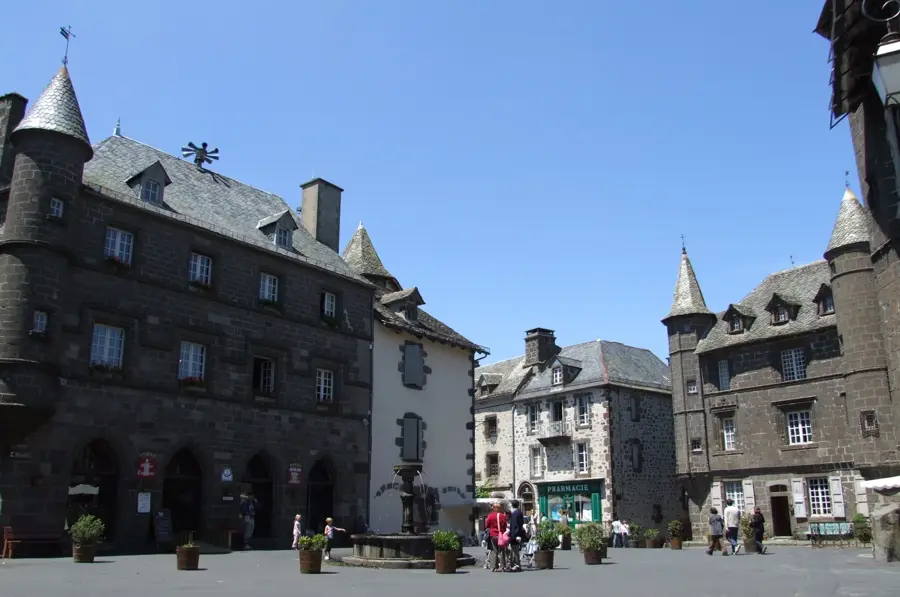
Salers sits in the heart of the Volcans d'Auvergne Regional Natural Park, perched on a rocky outcrop at 950 meters altitude. Listed as one of the 'Most Beautiful Villages of France', it is striking for its uniform architecture of dark volcanic stone (basalt) and grey slate roofs. Once a key administrative town in Auvergne, Salers has perfectly preserved its Renaissance character, featuring noble houses with pepper-pot turrets and coats of arms above the doorways. The town center is the Place Tyssandier-d'Escous, surrounded by grand buildings like the Maison de la Ronade. The Church of Saint-Mathieu houses a magnificent 15th-century 'Entombment of Christ' sculpture and rare 17th-century tapestries. Walking along the ancient ramparts provides sweeping views over the Maronne and Aspre valleys and the surrounding peaks of the Massif Central. Salers is synonymous with its famous cheese, a savory raw-milk hard cheese produced only in summer. Equally famous is the Salers cattle breed, known for its mahogany coat and lyre-shaped horns. The area is a prime destination for hiking to the Puy Mary or exploring the wild landscapes of the Cantal. The village is best reached by car via Aurillac, as it is located in a remote but exceptionally scenic part of central France.
- Location: Auvergne-Rhône-Alpes, France
- Top sights: Chapelle monolithique Saint-Michel · Château de Palmont · Point de vue de Barrouze
- Nearby: Aurillac (24 km)
Best time to visit & climate
The most pleasant time to visit is Jun–Aug.
| Jan | Feb | Mar | Apr | May | Jun | Jul | Aug | Sep | Oct | Nov | Dec | |
|---|---|---|---|---|---|---|---|---|---|---|---|---|
| Avg °C | 1 | 1 | 4 | 8 | 11 | 16 | 18 | 18 | 14 | 10 | 5 | 2 |
| Rain mm | 76 | 55 | 74 | 84 | 93 | 74 | 62 | 74 | 69 | 81 | 88 | 80 |
📋 Practical info
Geography
Facts
- One of the 'Most Beautiful Villages of France'
- Architecture made of black volcanic stone
- Home of the Salers cheese (AOP)
- Famous for the mahogany Salers cattle
- Situated at 950 meters altitude
- Renaissance houses with turrets
- 15th-century Entombment in the church
- Gateway to the Volcans d'Auvergne Park
Explore nearby
Notable places around
Route planner — Car & Motorhome
Where do you start? We build the route here, with stops and country notes along the way.
© OpenStreetMap contributors · OpenRouteService
Sights in the town Salers (11)
Sights nearby
Frequently asked questions
What stone is the village built from?
What is Salers cheese?
Are there viewpoints?
Can you see the cattle?
Are there local specialty shops?
Salers: where is it located?
Salers: what is there to see?
Salers: when is the best time to visit?
Salers: why is it worth visiting?

Nearby cities