Plizio Visual Lab
Chuquicamata
Weather…
Water temperature…
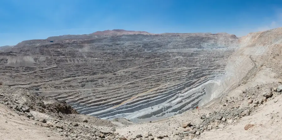
Chuquicamata is a colossal monument to industrial engineering, operating as a massive open-pit copper mine for over a century. The sheer scale of the crater is staggering, measuring over 4.3 kilometers long, 3 kilometers wide, and exceeding 1,000 meters in depth. Giant haul trucks, which look like small toys from the viewing platforms, constantly navigate the terraced walls. The operation transitioned primarily to underground mining in 2019 to access deeper reserves. Adjacent to the pit lies the abandoned Chuquicamata camp. Once home to over 25,000 miners and their families, the town was closed in 2007 due to environmental regulations and the expansion of the mine. Today, visitors can walk through the deserted streets on guided tours, observing the preserved central plaza, the historic clubhouses, and the old hospital. It provides a stark look at the history of the Chilean mining industry. Access to the site is strictly through organized tours departing from the nearby city of Calama, located 16 kilometers away. Advanced booking is mandatory due to active mining operations. The climate is extremely arid and sunny year-round. It is advisable to wear layered clothing, as morning temperatures can be freezing before warming up significantly in the afternoon.
- Location: Chile
- Nearby: Pica (86 km)
Best time to visit & climate
The most pleasant time to visit is Jan, Feb, Dec.
| Jan | Feb | Mar | Apr | May | Jun | Jul | Aug | Sep | Oct | Nov | Dec | |
|---|---|---|---|---|---|---|---|---|---|---|---|---|
| Avg °C | 17 | 16 | 16 | 14 | 11 | 10 | 10 | 11 | 13 | 14 | 16 | 16 |
| Rain mm | 8 | 9 | 6 | 1 | 2 | 0 | 1 | 1 | 0 | 0 | 1 | 4 |
📋 Practical info
Geography
Facts
- World's largest open-pit copper mine.
- Pit is over 4.3 kilometers long.
- Mine depth exceeds 1,000 meters.
- Operated for over a century.
- Adjacent town was abandoned in 2007.
- Transitioned to underground mining in 2019.
- Located 16 km from Calama.
- Advanced booking required for tours.
Explore nearby
Notable places around
Route planner — Car & Motorhome
Where do you start? We build the route here, with stops and country notes along the way.
© OpenStreetMap contributors · OpenRouteService
Sights in the town Chuquicamata (1)
Sights nearby
Frequently asked questions
Chuquicamata: where is it located?
Chuquicamata: when is the best time to visit?
Chuquicamata: why is it worth visiting?

Nearby cities