Plizio Visual Lab
Sennar Dam Region

Weather…
Water temperature…
The Sennar Dam was completed in 1925 on the Blue Nile and stands as one of the most significant engineering feats of the colonial era in Sudan. The structure spans 3025 meters in length and reaches a maximum height of 40 meters, primarily serving the irrigation needs of the massive Gezira Scheme. This agricultural initiative enabled the large-scale cultivation of cotton, which fundamentally reshaped the economic structure of the region and the entire country. The reservoir created by the dam regulates the flow of the Blue Nile, providing a steady water supply for thousands of kilometers of irrigation canals. Beyond its agricultural role, the dam is a key contributor to local hydroelectric power generation and supports a thriving inland fishing industry. The area surrounding the dam has evolved into a center for agricultural research and production, critical for Sudan's national food security. Today, it remains a point of interest for domestic visitors who appreciate its monumental technical design and the lush greenery of the nearby gardens.
- Location: Sudan
- Nearby: Maiurno (12 km)
Best time to visit & climate
The most pleasant time to visit is Jan, Feb, Dec.
| Jan | Feb | Mar | Apr | May | Jun | Jul | Aug | Sep | Oct | Nov | Dec | |
|---|---|---|---|---|---|---|---|---|---|---|---|---|
| Avg °C | 25 | 28 | 30 | 33 | 33 | 31 | 28 | 27 | 28 | 30 | 29 | 26 |
| Rain mm | 0 | 0 | 0 | 2 | 27 | 50 | 136 | 149 | 69 | 29 | 1 | 0 |
📋 Practical info
Geography
Facts
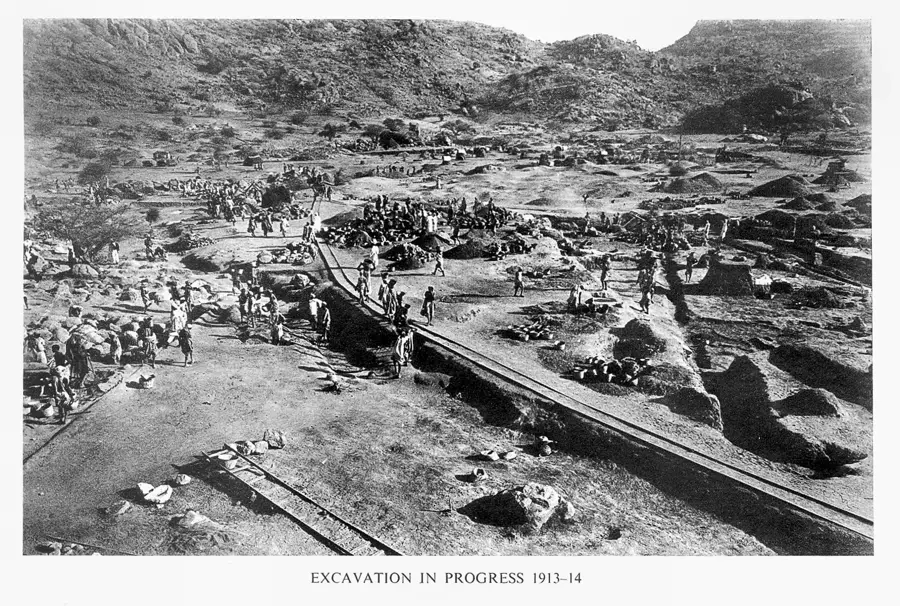
- Construction began in 1914 but was delayed by the First World War.
- The dam consists of a central masonry section and two earth embankments.
- It was officially opened in January 1926.
- The reservoir has a storage capacity of approximately 0.93 billion cubic meters.
- It supplies water to over 800,000 hectares of land in the Gezira Scheme.
- The dam features 80 sluice gates to manage water discharge.
Explore nearby
Notable places around
Route planner — Car & Motorhome
Where do you start? We build the route here, with stops and country notes along the way.
© OpenStreetMap contributors · OpenRouteService
Sights nearby
Frequently asked questions
What is the Sennar Dam?
Is the area open to visitors?
How do you get there?
Are there restaurants there?
What is nearby?
Sennar Dam Region: where is it located?
Sennar Dam Region: when is the best time to visit?
Sennar Dam Region: why is it worth visiting?

Nearby cities
History & landmarks
More places