Plizio Visual Lab

Mount Gabriel

Plizio editorial teamData Sources
Mountain
—°7
Mount Gabriel (Ireland)

Weather…

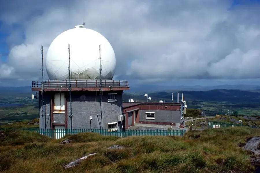
Mount Gabriel stands at 407 metres on the Mizen Peninsula in southwest County Cork. It is widely recognised for the two prominent white radar domes on its summit, which are used for monitoring North Atlantic air traffic. Geologically, the mountain is composed of Old Red Sandstone and features panoramic views of Roaringwater Bay, Fastnet Rock, and the surrounding islands. Of particular historical significance are the more than 25 Bronze Age copper mines on its flanks, which are among the best-preserved examples of their kind in Europe. Archaeological investigations show that copper ore was being extracted here using stone tools over 3,500 years ago. The landscape around Mount Gabriel is characterised by extensive blanket bogs, providing a habitat for a variety of bog plants and birdlife. Today, the mountain is an easily accessible destination for hikers and those interested in both ancient history and modern technology.

Best time to visit & climate

The most pleasant time to visit is Jul–Sep.

JanFebMarAprMayJunJulAugSepOctNovDec
Avg °C8789111415151412108
Rain mm143106988689919710498134143148

📋 Practical info

🧭
Getting there
The prominent mountain is located in the beautiful southwest of Cork and is exceptionally easily accessible via a paved access road that leads up the slope in tight curves from the nearby coastal village of Schull.
📅
Best season
The mountain can be easily visited year-round due to the robust, paved access road. However, clear summer days offer by far the most spectacular and far-reaching views over the many small islands of Roaringwater Bay.
⛰️
Terrain & paths
The presence of a well-maintained paved maintenance road for the massive radar domes makes the ascent very simple and straightforward. Off-road sections alongside it, however, are rocky and covered in extremely rough, thick heather.
🎒
What to bring
Light, comfortable walking shoes are completely sufficient and pleasant if you strictly remain on the paved road. A strong windbreaker is highly recommended, as the prominent peak is mercilessly exposed to strong coastal gales.
🅿️
Parking
Visitors often prefer to park right at the base of the mountain or partially along the wider spots of the access road. Strictly ensure that you do not under any circumstances block the vital maintenance vehicles for the radar installations.
⚠️
Safety
Do not leave the safe road under any circumstances in foggy conditions or generally poor visibility, to avoid dangerous falls on the rocky slopes. The fenced radar installations on the summit themselves are strictly restricted areas and inaccessible.
⏱️
Time needed
The leisurely walk up the curving maintenance road all the way to the top and back generally takes about two hours, making it an excellent short excursion with incredibly rewarding coastal panoramas.

Geography

Coordinates
51.53330, -9.51670

Facts

  • The height of Mount Gabriel is 407 metres.
  • The radar domes are operated by Eurocontrol.
  • There are over 25 Bronze Age copper mines on the mountain.
  • Mining activity here dates between 1700 and 1500 BC.
  • The mountain consists of Devonian Old Red Sandstone.
  • Fastnet Rock, Ireland's most southerly point, is visible from the top.

Explore nearby

Notable places around

Route planner — Car & Motorhome

Where do you start? We build the route here, with stops and country notes along the way.

Vehicle
Only stops with (optional):

© OpenStreetMap contributors · OpenRouteService

Sights in the town Mount Gabriel (7)

Copper Point Lighthouse📍 landmark

A coastal lighthouse at Mount Gabriel that aids ships with navigation.

Rossbrin Castle🏰 castle

The ruins of a medieval coastal castle located near Mount Gabriel.

Trá na hAidhleann🎡 recreation

A scenic beach at Mount Gabriel, well-suited for coastal relaxation.

Mount Gabriel📍 landmark

A prominent mountain peak in West Cork, known for its wide views and radar domes.

Mount Gabriel View Point toward North🌿 nature

Mount Gabriel View Point toward North gives panoramic views of the landscape.

Pierre levée🏺 historical

An ancient megalithic monument found in the Mount Gabriel area.

St. Mary’s church🏺 historical

The remains of a historical church located near Mount Gabriel.

Sights nearby

Frequently asked questions

Where is Mount Gabriel located?
On the Mizen Peninsula in West County Cork.
What is located on the summit?
Two large white radar domes used for monitoring transatlantic air traffic.
Are there archaeological sites there?
Yes, there are prehistoric copper mines from the Bronze Age on the mountain.
How high is Mount Gabriel?
The summit is at 407 meters.
Can you drive to the summit?
Yes, a narrow service road leads to the radar stations, offering great views.
Mount Gabriel: where is it located?
Mount Gabriel is located in Ireland.
Mount Gabriel: what is there to see?
Highlights include Copper Point Lighthouse, Rossbrin Castle, Trá na hAidhleann.
Mount Gabriel: when is the best time to visit?
The most pleasant time to visit is Jul, Sep.
Mount Gabriel: why is it worth visiting?
Mount Gabriel stands at 407 metres on the Mizen Peninsula in southwest County Cork.
View on map → The Top 50 Attractions → Most beautiful beaches → OpenStreetMap →
Europe
Explore with Plizio Discover more places in Europe
More places in Ireland →

Nearby cities