Plizio Visual Lab
Pico do Fogo
Weather…
Water temperature…
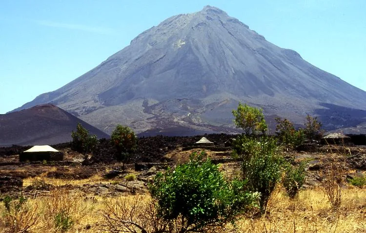
Pico do Fogo is a prominent volcanic elevation in the southern part of São Tomé Island, located within the boundaries of the protected Obô National Park. Despite its fiery name, which recalls its volcanic origins, it is a long-extinct volcanic cone that is now completely covered by dense primary montane rainforest. Standing over 1,300 meters high, it is part of the island's mountainous backbone and shapes the relief of the Caué district through its steep slopes. The region around the summit is known for its extremely high humidity and frequent mists, which have fostered the development of a unique flora featuring numerous endemic orchids and ferns. Geologically, the mountain is part of the volcanic Cameroon Line, formed millions of years ago by hotspot activity in the Atlantic. Hiking trails in this area are very challenging due to the dense vegetation and rugged terrain, and are mostly used only by experienced climbers and researchers. Pico do Fogo also serves as a vital water reservoir feeding numerous streams in the south of the island.
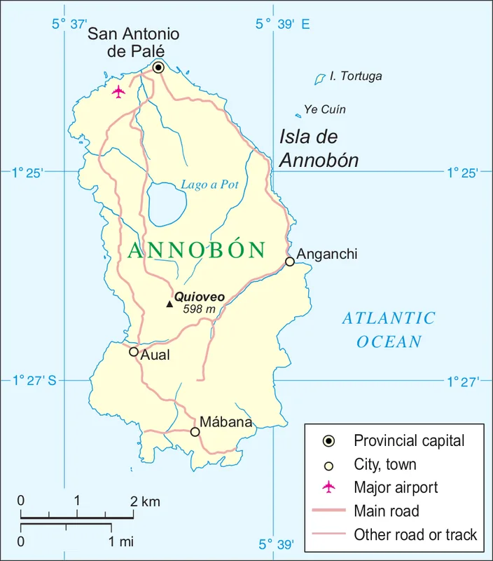
- Location: Equatorial Guinea
- Top sights: Lapá Faanguyí · Macizo Santa Mina
Best time to visit & climate
The most pleasant time to visit is Jun–Aug.
| Jan | Feb | Mar | Apr | May | Jun | Jul | Aug | Sep | Oct | Nov | Dec | |
|---|---|---|---|---|---|---|---|---|---|---|---|---|
| Avg °C | 27 | 27 | 28 | 28 | 27 | 24 | 23 | 24 | 25 | 26 | 26 | 27 |
| Rain mm | 143 | 133 | 163 | 150 | 67 | 9 | 4 | 4 | 6 | 28 | 79 | 129 |
📋 Practical info
Geography
Facts
- Reaches an elevation of 1,312 meters.
- Part of the Obô National Park mountain massif.
- The last volcanic eruption occurred millions of years ago.
- Home to over 20 endemic bird species.
- The soil consists of fertile volcanic basalt.
- Often shrouded in clouds with over 90% humidity.
Explore nearby
Notable places around
Route planner — Car & Motorhome
Where do you start? We build the route here, with stops and country notes along the way.
© OpenStreetMap contributors · OpenRouteService
Sights in the town Pico do Fogo (2)
Sights nearby
Frequently asked questions
Where is Pico do Fogo located?
Is the mountain an active volcano?
What does the name mean?
How difficult is the terrain?
Is there a crater lake nearby?
Pico do Fogo: where is it located?
Pico do Fogo: what is there to see?
Pico do Fogo: when is the best time to visit?
Pico do Fogo: why is it worth visiting?

Nearby cities

History & landmarks
More places