Plizio Visual Lab
Chocolate Hills
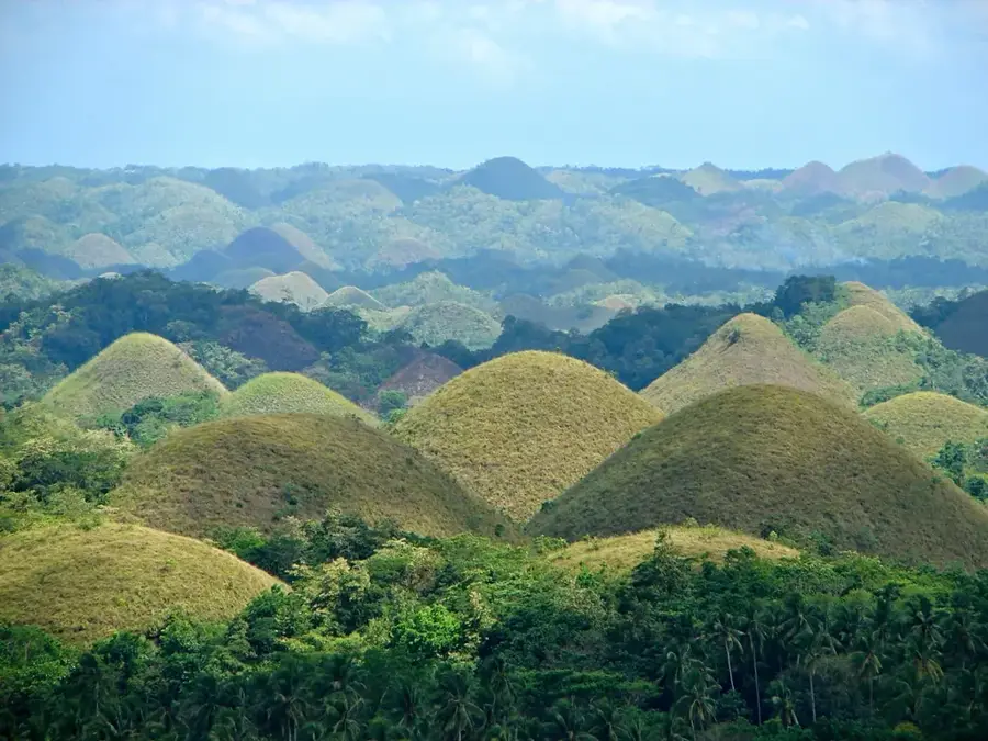
The Chocolate Hills are a remarkable geological formation in Bohol province, consisting of at least 1,260 symmetrical conical hills spread over an area of more than 50 square kilometers. These hills are composed of grass-covered limestone containing marine fossils, formed by the uplift of coral deposits and subsequent erosion by rainwater over millions of years. They derive their name from the grass that turns chocolate brown during the dry season, making the landscape resemble an array of giant Hershey's Kisses. The hills generally range from 30 to 50 meters in height, with the largest reaching 120 meters. Their striking uniformity has led to local legends and even early theories of man-made origins, though they are confirmed to be natural karst formations. Currently on the UNESCO World Heritage tentative list, they are designated as a National Geological Monument. Viewing decks in the towns of Carmen and Sagbayan provide the most comprehensive vistas of this unique terrain.
- Location: Philippines
- Top sights: Hill Top 360 degee View Park · The Captain's Peak Garden & Resort · Grace Life Bible Church
- Nearby: Buenavista (15 km)
Best time to visit & climate
The most pleasant time to visit is Feb–Apr.
| Jan | Feb | Mar | Apr | May | Jun | Jul | Aug | Sep | Oct | Nov | Dec | |
|---|---|---|---|---|---|---|---|---|---|---|---|---|
| Avg °C | 26 | 26 | 27 | 28 | 29 | 28 | 27 | 27 | 27 | 27 | 27 | 27 |
| Rain mm | 153 | 99 | 86 | 65 | 117 | 198 | 220 | 184 | 193 | 226 | 169 | 183 |
📋 Practical info
Geography
Facts
- Estimates of the total number of hills range from 1,260 to 1,776.
- The hills are spread across the towns of Carmen, Batuan, and Sagbayan.
- Composed of late Pliocene to early Pleistocene marine limestone.
- Declared a National Geological Monument on June 18, 1988.
- The brown hue is most prominent during the months of February to May.
- They are featured prominently on the provincial flag of Bohol.
Explore nearby
Notable places around
Route planner — Car & Motorhome
Where do you start? We build the route here, with stops and country notes along the way.
© OpenStreetMap contributors · OpenRouteService
Sights in the town Chocolate Hills (7)
Sights nearby
Frequently asked questions
How many hills are there really?
Why are they called Chocolate Hills?
Is there a viewing deck?
Is the visit suitable for children?
How to get to the hills?
Chocolate Hills: where is it located?
Chocolate Hills: what is there to see?
Chocolate Hills: when is the best time to visit?
Chocolate Hills: why is it worth visiting?

Nearby cities


More places