Alor Setar Tower
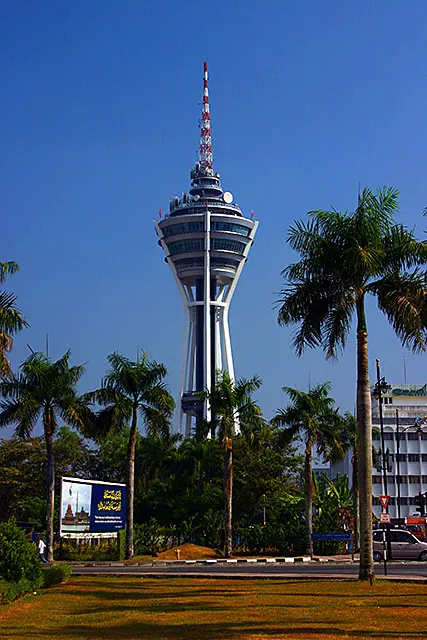
The Alor Setar Tower (Menara Alor Setar) stands as a prominent landmark in the heart of Alor Setar, the capital city of Kedah, Malaysia. Soaring to a height of 165.5 meters, it is primarily a telecommunications tower but has also become a major tourist attraction. Completed in 1997, its distinctive architecture is said to resemble a tied sheaf of rice stalks, paying homage to Kedah's status as the "Rice Bowl of Malaysia."
Visitors taking the swift elevator to the observation deck are rewarded with breathtaking panoramic views of the city, extending across vast, lush green paddy fields and out to the Straits of Malacca on a clear day. The tower also hosts a revolving restaurant, allowing guests to enjoy a meal while the scenery slowly changes around them, providing a memorable dining experience above the bustling city streets.
Beyond its panoramic views and dining options, the Alor Setar Tower serves as a crucial hub for telecommunications and broadcasting in the northern region of Peninsular Malaysia. It is also an important observation point for spotting the crescent moon to mark the beginning of Muslim fasting months. The base of the tower frequently hosts cultural events and local markets, making it a lively community gathering space.
Weather…
Best time to visit & climate
The most pleasant time to visit is Jan–Mar.
| Jan | Feb | Mar | Apr | May | Jun | Jul | Aug | Sep | Oct | Nov | Dec | |
|---|---|---|---|---|---|---|---|---|---|---|---|---|
| Avg °C | 25 | 26 | 27 | 27 | 27 | 27 | 26 | 26 | 26 | 26 | 26 | 25 |
| Rain mm | 113 | 50 | 117 | 158 | 202 | 155 | 171 | 199 | 235 | 298 | 341 | 265 |
Practical info
Tips
- Visit on a clear, sunny day for the best visibility.
- Consider booking a table at the revolving restaurant in advance for a unique dining experience.
FAQ
What is the Alor Setar Tower?
When is the best time to visit?
Is the observation deck accessible to tourists?
What can be seen from the top?
How can I reach the tower?
Route planner — Car & Motorhome
Where do you start? We build the route here, with stops and country notes along the way.
© OpenStreetMap contributors · OpenRouteService