Catumbela Saint Peter's Redoubt
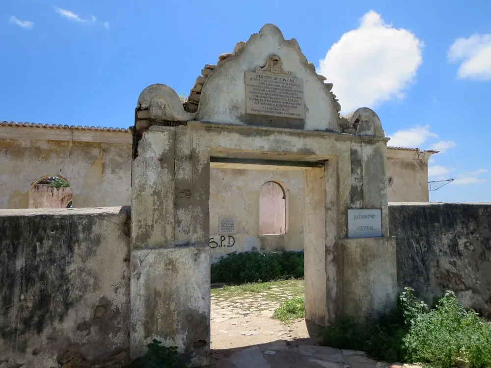
The Catumbela Saint Peter's Redoubt (Reduto de São Pedro de Catumbela) is a significant colonial military fortification situated on an elevated vantage point in Catumbela, Angola. Constructed around 1846, this well-preserved redoubt was built to secure trade routes and protect the settlement. Its strategic location on a rugged hill provided a commanding view of the Catumbela River and the crucial transport corridors connecting the interior with the coastal city of Benguela.
Visiting the redoubt today offers a profound connection to Angola's complex historical heritage. The fort's robust stone walls, battlements, and central courtyard remain largely intact, serving as a silent witness to the 19th-century trade dynamics. Although relatively compact, its well-thought-out defensive design makes it a fascinating piece of military architecture and a recognized national cultural monument.
Beyond its historical significance, the redoubt is renowned for its breathtaking panoramic views. Visitors who make the short trek up the hill are rewarded with sweeping vistas of the Catumbela River winding toward the Atlantic Ocean, the iconic bridges spanning its waters, and the expansive Angolan landscape. It is a highly recommended stop for history enthusiasts exploring the province.
Weather…
Best time to visit & climate
The most pleasant time to visit is Jun–Aug.
| Jan | Feb | Mar | Apr | May | Jun | Jul | Aug | Sep | Oct | Nov | Dec | |
|---|---|---|---|---|---|---|---|---|---|---|---|---|
| Avg °C | 25 | 25 | 25 | 26 | 25 | 23 | 22 | 22 | 23 | 25 | 25 | 24 |
| Rain mm | 77 | 76 | 109 | 67 | 4 | 1 | 0 | 3 | 13 | 40 | 126 | 62 |
Practical info
Tips
- Bring drinking water for the hike up.
- A great spot for panoramic landscape photography.
FAQ
What is the Reduto de São Pedro?
When was the fort built?
How do you get to the redoubt?
What can you see from the top?
Is there an entrance fee?
Route planner — Car & Motorhome
Where do you start? We build the route here, with stops and country notes along the way.
© OpenStreetMap contributors · OpenRouteService