Plizio Visual Lab
Müller Mountains
Weather…
Water temperature…
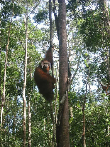
The Müller Mountains stretch across the center of Borneo (Kalimantan), forming a natural boundary between West and East Kalimantan. The range was named after the German naturalist Georg Müller, who explored the region in the early 19th century. It serves as the island's primary watershed, providing the sources for major rivers including the Kapuas, Mahakam, and Barito. The geography is characterized by inaccessible primary rainforests and rugged sandstone formations that harbor immense biodiversity. Due to its extreme remoteness, the mountains remain one of the least explored areas in Indonesia, acting as a crucial sanctuary for endangered species like orangutans. The range also holds great cultural significance for the Dayak tribes living in the lower valleys, who regard the high peaks as sacred ancestral domains.
Best time to visit & climate
The most pleasant time to visit is Jul–Sep.
| Jan | Feb | Mar | Apr | May | Jun | Jul | Aug | Sep | Oct | Nov | Dec | |
|---|---|---|---|---|---|---|---|---|---|---|---|---|
| Avg °C | 24 | 24 | 24 | 24 | 24 | 24 | 23 | 23 | 24 | 24 | 24 | 24 |
| Rain mm | 328 | 301 | 347 | 343 | 275 | 217 | 172 | 164 | 177 | 283 | 354 | 389 |
📋 Practical info
Geography
Facts
- Named after naturalist Georg Müller
- Source of the Kapuas River
- Border of West and East Kalimantan
- Primary watershed of Borneo island
- Key sanctuary for wild orangutans
- Peak elevations exceeding 1000 meters
Route planner — Car & Motorhome
Where do you start? We build the route here, with stops and country notes along the way.
© OpenStreetMap contributors · OpenRouteService
Sights nearby
Frequently asked questions
Where are the Muller Mountains located?
How do you reach the Muller Mountains?
What is the Cross-Borneo trek?
Are there human settlements there?
What gear is needed for an expedition?
Müller Mountains: where is it located?
Müller Mountains: when is the best time to visit?
Müller Mountains: why is it worth visiting?